Clinton, Clinton County, New York
| Clinton, New York | |
|---|---|
| Town | |
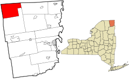
 Location in Clinton County and the state of New York. |
|
| Coordinates: 44°56′35″N 73°56′51″W / 44.94306°N 73.94750°WCoordinates: 44°56′35″N 73°56′51″W / 44.94306°N 73.94750°W | |
| Country | United States |
| State | New York |
| County | Clinton |
| Government | |
| • Type | Town Council |
| • Town Supervisor | Daniel L. LaClair (D) |
| • Town Council |
Members' List
|
| Area | |
| • Total | 67.1 sq mi (173.8 km2) |
| • Land | 67.1 sq mi (173.7 km2) |
| • Water | 0.04 sq mi (0.1 km2) |
| Elevation | 1,168 ft (356 m) |
| Population (2010) | |
| • Total | 737 |
| • Density | 11/sq mi (4.2/km2) |
| Time zone | Eastern (EST) (UTC-5) |
| • Summer (DST) | EDT (UTC-4) |
| FIPS code | 36-16397 |
| GNIS feature ID | 978840 |
Clinton is a town in Clinton County, New York, United States. The population was 737 at the 2010 census. The town is located in the northwest corner of the county and is northwest of Plattsburgh.
The area was settled before 1820 near the community of Frontier. The town was set apart from the town of Ellenburg in 1845.
According to the United States Census Bureau, the town of Clinton has a total area of 67.1 square miles (173.8 km2), of which 67.1 square miles (173.7 km2) is land and 0.04 square miles (0.1 km2), or 0.04%, is water.
The northern town line is the Canada–US border with Quebec in Canada, and the western town line is the border of the town of Chateaugay in Franklin County.
U.S. Route 11 is an east-west highway, which intersects New York State Route 189, a north-south highway, south of Churubusco.
As of the census of 2000, there were 727 people, 270 households, and 201 families residing in the town. The population density was 10.8 people per square mile (4.2/km²). There were 348 housing units at an average density of 5.2 per square mile (2.0/km²). The racial makeup of the town was 98.35% White, 0.28% African American, 0.14% Asian, 0.28% from other races, and 0.96% from two or more races. Hispanic or Latino of any race were 0.28% of the population.
...
Wikipedia
