Chybie
| Chybie | ||
|---|---|---|
| Village | ||

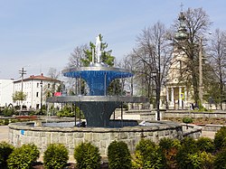
Fountain in Chybie downtown
|
||
|
||
| Coordinates: 49°53′41.8″N 18°48′47.88″E / 49.894944°N 18.8133000°E | ||
| Country |
|
|
| Voivodeship |
|
|
| County |
|
|
| Gmina | Chybie | |
| Government | ||
| • Administrator | Elżbieta Maria Dubiańska-Przemyk | |
| Area | 4.33 sq mi (11.22 km2) | |
| • Land | 4.33 sq mi (11.22 km2) | |
| • Water | 0 sq mi (0 km2) | |
| Elevation | 833 ft (254 m) | |
| Population (2012) | 3,900 | |
| • Estimate (2012) | 3,903 | |
| • Rank | 9th in Cieszyn | |
| • Density | 901.4/sq mi (347.9/km2) | |
| Time zone | CET (UTC+1) | |
| • Summer (DST) | CEST (UTC+2) | |
| ZIP code | 43-520 | |
| Area code(s) | 33 | |
| Car plates | SCI | |
| SIMC feature ID | 0050765 | |
| Website | www.chybie.pl | |
![]() Chybie is a village and the seat of Gmina Chybie in Cieszyn County, Silesian Voivodeship, southern Poland. It has a population of 3,903 (2012).
Chybie is a village and the seat of Gmina Chybie in Cieszyn County, Silesian Voivodeship, southern Poland. It has a population of 3,903 (2012).
It lies in the Upper Vistula Valley within Oświęcim Basin and in the historical region of Cieszyn Silesia. There is a nature reserve called Rotuz in the easter part of the village.
It was first mentioned in a written document in 1568 as Zeleny Chyb. Politically it belonged then to the Duchy of Teschen, a fee of the Kingdom of Bohemia, which after 1526 became part of the Habsburg Monarchy.
After Revolutions of 1848 in the Austrian Empire a modern municipal division was introduced in the re-established Austrian Silesia. The village as a municipality was subscribed to the political district of Bielsko and the legal district of Strumień. A sugar mill was established by Teschener Kammer in the village in 1884 (defunct since 2009).
...
Wikipedia


