Churchill County, Nevada
| Churchill County, Nevada | ||
|---|---|---|
| County | ||
| Churchill County | ||

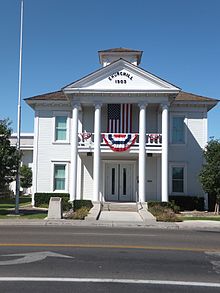
Churchill County Courthouse in Fallon
|
||
|
||
 Location in the U.S. state of Nevada |
||
 Nevada's location in the U.S. |
||
| Founded | 1861 | |
| Named for | Sylvester Churchill | |
| Seat | Fallon | |
| Largest city | Fallon | |
| Area | ||
| • Total | 5,024 sq mi (13,012 km2) | |
| • Land | 4,930 sq mi (12,769 km2) | |
| • Water | 94 sq mi (243 km2), 1.9% | |
| Population | ||
| • (2010) | 24,877 | |
| • Density | 5.0/sq mi (2/km²) | |
| Congressional district | 2nd | |
| Time zone | Pacific: UTC-8/-7 | |
| Website | churchillcounty |
|
Churchill County is a county located in the western U.S. state of Nevada. As of the 2010 census, the population was 24,877. Its county seat is Fallon. The county, named after Mexican-American War hero brevet Brigadier General Sylvester Churchill, was formed in 1861.
Churchill County comprises the Fallon, NV Micropolitan Statistical Area. It is located in northwestern Nevada.
Churchill County is noteworthy in that it owns and operates the local telephone carrier, Churchill County Communications.
Churchill County was established in 1861 and named after Fort Churchill (which is now in Lyon County), which was named after General Sylvester Churchill, a Mexican-American War hero who was Inspector General of the U.S. Army in 1861. Churchill County was not organized until 1864, and its county seats were Bucklands (1861–64) which is now in Lyon County, La Plata (1864–68), Stillwater (1868–1904) and Fallon (1904–present). In the 19th century there were several attempts to eliminate Churchill County because of its small population, but Assemblyman Lemuel Allen was able to stop it on all occasions including convincing the Governor to veto the bill after it had been passed by both houses in 1875.
...
Wikipedia

