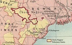
Chota Nagpur Tributary States
| Chota Nagpur Tributary States | |||||
| Group of princely states of British India | |||||
|
|||||
| History | |||||
| • | Sanads issued to Chota Nagpur rulers | 1821 | |||
| • | Accession to the Indian Union | 1947 | |||
| Area | |||||
| • | 1881 | 41,580 km2(16,054 sq mi) | |||
| Population | |||||
| • | 1881 | 678,002 | |||
| Density | 16.3 /km2 (42.2 /sq mi) | ||||
| Today part of | Chhattisgarh, Jharkhand and Odisha | ||||
The Chota Nagpur Tributary States or Chota Nagpur States were a group of non-salute states (minor princely states) at the time of British Raj, located on the Chhota Nagpur Plateau. British suzerainty over the states was exercised through the government of the Bengal Presidency.
These states were nine in number and they became part of the Indian states of Madhya Pradesh, Bihar and Orissa following Indian Independence.
In the 18th century, the states came within the sphere of influence of the Maratha Empire, but they became tributary states of British India as a result of the Anglo-Maratha Wars in the early 19th century.
In October 1905, the exercise of British influence over the predominantly Hindi-speaking states of Chang Bhakar, Jashpur, Koriya, Surguja, and Udaipur was transferred from the Bengal government to that of the Central Provinces, while the two Oriya-speaking states of Gangpur and Bonai were attached to the Orissa Tributary States, leaving only Kharsawan and Saraikela answerable to the Bengal governor.
In 1936, all nine states were transferred to the Eastern States Agency, the officials of which came under the direct authority of the Governor-General of India, rather than under that of any Provinces.
After Indian independence in 1947, the rulers of the states all chose to accede to the Dominion of India. Changbhakar, Jashpur, Koriya, Surguja and Udaipur later became part of Madhya Pradesh state, but Gangpur and Bonai part of Orissa state, and Kharsawan and Saraikela part of Bihar state.
...
Wikipedia

