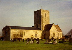
Cholsey
| Cholsey | |
|---|---|
 St. Mary's parish church |
|
| Cholsey shown within Oxfordshire | |
| Area | 16.52 km2 (6.38 sq mi) |
| Population | 3,380 (2001 census) |
| • Density | 205/km2 (530/sq mi) |
| OS grid reference | SU5886 |
| • London | 45 mi (72 km) |
| Civil parish |
|
| District | |
| Shire county | |
| Region | |
| Country | England |
| Sovereign state | United Kingdom |
| Post town | Wallingford |
| Postcode district | OX10 |
| Dialling code | 01491 |
| Police | Thames Valley |
| Fire | Oxfordshire |
| Ambulance | South Central |
| EU Parliament | South East England |
| UK Parliament | |
| Website | Cholsey Parish Council |
Cholsey is a village and large civil parish two miles (3 km) south of Wallingford, in South Oxfordshire. In 1974 it was transferred from Berkshire to the county of Oxfordshire, and from Wallingford Rural District to the district of South Oxfordshire.
Cholsey's parish boundaries, some 17 miles (27 km) long, reach from the edge of Wallingford into the Berkshire Downs. The village green is known as The Forty and has a substantial and ancient walnut tree. Winterbrook was historically at the north end of the parish adjoining Wallingford and became within Wallingford parish (run by its Town Council) since 2015. It is the site of Winterbrook Bridge, which carries a by-pass road across the Thames, and was one of the two main residences of the late author Dame Agatha Christie (the other being the village of Galmpton on the south Devon coast). John Masefield, poet laureate, was a resident of Cholsey.
A Bronze Age site has been found beside the River Thames at Whitecross Farm in the northeast of the parish. A pre-Roman road, the Icknield Way, crosses the River Thames at Cholsey.
The village itself was founded on an island (Ceol's Isle) in marshy ground close to the Thames. There is evidence that the House of Wessex Royal family owned land in Cholsey in the 6th and 7th centuries. At this time the town was home to a Saint Wilgyth who was venerated locally in the Middle Ages.
...
Wikipedia

