Choisy-le-Roi
| Choisy-le-Roi | ||
|---|---|---|

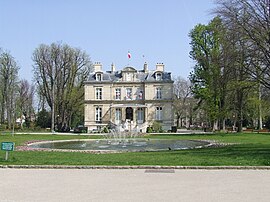
The town hall of Choisy-le-Roi
|
||
|
||
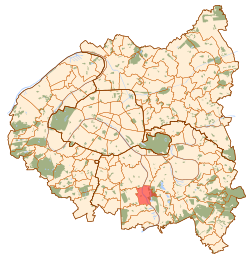
 Paris and inner ring departments |
||
| Coordinates: 48°45′47″N 2°24′32″E / 48.763°N 2.409°ECoordinates: 48°45′47″N 2°24′32″E / 48.763°N 2.409°E | ||
| Country | France | |
| Region | Île-de-France | |
| Department | Val-de-Marne | |
| Arrondissement | Créteil | |
| Canton | Choisy-le-Roi | |
| Government | ||
| • Mayor (2008–2014) | Daniel Davisse | |
| Area1 | 5.43 km2 (2.10 sq mi) | |
| Population (2006)2 | 37,486 | |
| • Density | 6,900/km2 (18,000/sq mi) | |
| Time zone | CET (UTC+1) | |
| • Summer (DST) | CEST (UTC+2) | |
| INSEE/Postal code | 94022 /94600 | |
| Elevation | 31–49 m (102–161 ft) (avg. 40 m or 130 ft) |
|
|
1 French Land Register data, which excludes lakes, ponds, glaciers > 1 km² (0.386 sq mi or 247 acres) and river estuaries. 2Population without double counting: residents of multiple communes (e.g., students and military personnel) only counted once. |
||
1 French Land Register data, which excludes lakes, ponds, glaciers > 1 km² (0.386 sq mi or 247 acres) and river estuaries.
Choisy-le-Roi is a commune in the Val-de-Marne department in the southeastern suburbs of Paris, France.
Choisy-le-Roi is located 10.7 km (6.6 mi) southeast from the center of Paris, on both banks of the river Seine. The neighbouring communes are, from the north and clockwise: Vitry-sur-Seine, Alfortville, Créteil, Valenton, Villeneuve-Saint-Georges, Orly and Thiais.
Choisy-le-Roi is served by Choisy-le-Roi station on Paris RER line C. It is also served by Créteil-Pompadour station on Paris RER line D.
Public schools include:
There is a private school serving elementary to senior high school, groupe scolaire Saint André Choisy-le-Roi.
Choisy-le-Roi is twinned with:
...
Wikipedia

