Valenton
| Valenton | |
|---|---|

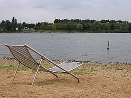
Plage Bleue park
|
|
 Paris and inner ring departments |
|
| Coordinates: 48°44′42″N 2°28′02″E / 48.745°N 2.4672°ECoordinates: 48°44′42″N 2°28′02″E / 48.745°N 2.4672°E | |
| Country | France |
| Region | Île-de-France |
| Department | Val-de-Marne |
| Arrondissement | Créteil |
| Canton | Valenton |
| Government | |
| • Mayor (2008–2014) | Daniel Tousaint |
| Area1 | 5.31 km2 (2.05 sq mi) |
| Population (2006)2 | 12,382 |
| • Density | 2,300/km2 (6,000/sq mi) |
| Time zone | CET (UTC+1) |
| • Summer (DST) | CEST (UTC+2) |
| INSEE/Postal code | 94074 /94460 |
| Elevation | 32–87 m (105–285 ft) |
|
1 French Land Register data, which excludes lakes, ponds, glaciers > 1 km² (0.386 sq mi or 247 acres) and river estuaries. 2Population without double counting: residents of multiple communes (e.g., students and military personnel) only counted once. |
|
1 French Land Register data, which excludes lakes, ponds, glaciers > 1 km² (0.386 sq mi or 247 acres) and river estuaries.
Valenton is a commune in the southeastern suburbs of Paris, France. It is located 15.1 km (9.4 mi) from the center of Paris. It extends over 531 hectares of which 84 are green spaces. The most important public green space is the Plage Bleue Park where different events are organized every year. Among them, we have the Festival de l’Oh focused on environmental issues dealing with aquatic resources. Valenton is surrounded by the towns of Choisy-le-Roi, Créteil, Crosne, Limeil-Brévannes, Villeneuve-Saint-Georges and Yerres. The town can be reached through the motorway A86 and the main road RN6. It is connected to the suburban rail network with the RER line D (Villeneuve Triage and Villeneuve-Saint-Georges, the two closest stations) or RER line A at Boissy-Saint-Léger.
Valenton was born in the 6th century. It was a dependency of the abbey of Saint-Germain-Des-Prés. The first inhabitants were mainly farmers specialized in viticulture. In 1726, it was still a village and had 250 inhabitants. Two centuries later, the population grew to about 1,000 inhabitants. The main activities became livestock farming and market gardening. The town extended in 1936 with the construction of two new residential areas (Les Vignes and Val Pompadour). At this time, the population was only 2,448. The town which was a strategic point during the Second World War was heavily bombarded by the Anglo-American aviation, which caused many casualties among the civil population. The aim for this heavy pounding induced by this air raid was to destroy the strategic marshalling yard of Villeneuve-Saint-Georges close to the Val Pompadour residential area. After the war, the town grew considerably. By 1962, the population reached 7,713 and in 1968 it was 10,539 inhabitants. Nowadays, 11,426 people live in the town.
The town is administered by Françoise BAUD since 2008. Valenton is one of the French Communist Party’s strongholds. In fact, it is ruled by the French Communist Party since 1920, two years before the creation of the USSR in 1922. The only exception was the period ranging from 1941 to 1944 when France was under the rule of the Government of Vichy. It is one of France’s first communes to have a female mayor (Fernande FLAGON).
Valenton hosts a water purification station. This town is strongly dedicated to the cause of the environmental improvement in urban areas. Hence the numerous green spaces in the heart of the town. More than 190 companies are located in its six business areas.
...
Wikipedia
