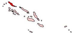
Choiseul Province
| Choiseul Province | ||
|---|---|---|
| Province | ||
|
||
 |
||
| Coordinates: 7°0′1″S 156°57′50″E / 7.00028°S 156.96389°E | ||
| Country |
|
|
| Capital | Taro Island | |
| Government | ||
| • Premier | Jackson Kiloe | |
| Area | ||
| • Total | 3,837 km2 (1,481 sq mi) | |
| Population (2009) | ||
| • Total | 26,379 | |
| • Density | 5.2/km2 (13/sq mi) | |
| Time zone | +11 (UTC+11) | |
Coordinates: 7°00′01″S 156°57′50″E / 7.00028°S 156.96389°E
The Choiseul Province is one of the nine provinces in Solomon Islands. It lies southeast of Bougainville (part of Papua New Guinea, west of Santa Isabel and north of Vella la Vella, Kolombangra & New Georgia. In the 2009 national census its population is 26,372.
The province consists of three major islands, which are Choiseul, Vaghena, and Rob Roy. Choiseul Island, which is commonly known as Lauru to the natives, has land area of 3,294 square kilometres (1,272 sq mi), Vaghena at 243 square kilometres (94 sq mi), and Rob Roy at 200 square kilometres (77 sq mi). Taro Island at 1.5 square kilometres (0.58 sq mi), is the capital of the province.
When the natives first arrived and discovered the big island, they called it Lauru. Then, in 1568, the Spanish explorer Álvaro de Mendaña de Neira rediscovered the island and named it San Marcos ('Saint Mark'). Mendana himself never set foot on Lauru. He called it San Marcos, because he saw the island from Santa Isabel on the Day of Saint Mark.
200 years later in 1768, the French explorer Louis Antoine de Bougainville saw the island again and named it Choiseul after the Minister of foreign affairs and statesman Choiseul.
...
Wikipedia

