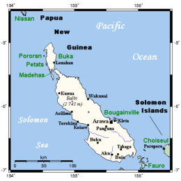
Bougainville Island

Bougainville and neighbouring islands
|
|
| Bougainville Island (Papua New Guinea) | |
| Geography | |
|---|---|
| Location | Melanesia |
| Coordinates | 6°14′40″S 155°23′02″E / 6.24444°S 155.38389°E |
| Archipelago | Solomon Islands |
| Area | 9,318 km2 (3,598 sq mi) |
| Highest elevation | 2,715 m (8,907 ft) |
| Highest point | Mount Balbi |
| Administration | |
|
Papua New Guinea
|
|
| Province | Bougainville Province |
| Demographics | |
| Population | 175,160 (2000) |
| Pop. density | 18.80 /km2 (48.69 /sq mi) |
| Additional information | |
| Time zone |
|
Bougainville Island is the main island of the Autonomous Region of Bougainville of Papua New Guinea. This region is also known as Bougainville Province or the North Solomons. Its land area is 9,300 km2. The population of the province is 175,160 (2000 census), which includes the adjacent island of Buka and assorted outlying islands including the Carterets. Mount Balbi at 2,700 m is the highest point. Although Bougainville Island is geographically part of the Solomon Islands archipelago, it is not a part of the state of Solomon Islands.
Bougainville was first settled some 28,000 years ago. Three to four thousand years ago, Austronesian people arrived, bringing with them domesticated pigs, chickens, dogs and obsidian tools. The first European contact with Bougainville was in 1768, when the French explorer Louis de Bougainville arrived and named the main island for himself.
Germany laid claim to Bougainville in 1899, annexing it into German New Guinea. Christian missionaries arrived on the island in 1902.
During World War I, Australia occupied German New Guinea, including Bougainville. It became part of the Australian Territory of New Guinea under a League of Nations mandate in 1920.
In 1942, during World War II, Japan invaded the island, but allied forces launched the Bougainville campaign to regain control of the island in 1943. Following the war, the Territory of New Guinea, including Bougainville, returned to Australian control.
...
Wikipedia

