Chernobyl Exclusion Zone
| Chernobyl Exclusion Zone (Ukrainian: Зона відчуження Чорнобильської АЕС) |
|
| Zone of Alienation, 30 kilometre Zone | |
| Exclusion area and disaster area | |
|
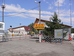
Entrance to the Chernobyl Exclusion Zone at Checkpoint "Dityatki"
|
|
| Official name: Chernobyl Nuclear Power Plant Zone of Alienation | |
| Named for: The Chernobyl Nuclear Power Plant after the disaster | |
| Country | |
|---|---|
| Oblasts | Kiev Oblast, Zhytomyr Oblast |
| Raions | Ivankiv Raion (includes former Chernobyl Raion), Poliske Raion, Narodychi Raion |
| Borders on | Belarus, Polesie State Radioecological Reserve |
| Cities | Chernobyl, Pripyat, Poliske |
| Landmarks | Kopachi, Red Forest |
| Buildings | Russian Woodpecker, Chernobyl Nuclear Power Plant and sarcophagus |
| River | Pripyat River |
| Coordinates | 51°18′00″N 30°00′18″E / 51.3°N 30.005°ECoordinates: 51°18′00″N 30°00′18″E / 51.3°N 30.005°E |
| Area | 2,600 km2 (1,004 sq mi) |
| Population | The Exclusion Zone is an "Area of Absolute (Mandatory) Resettlement".
A few hundred samosely have been permitted to remain. Employees of state agencies are resident in the Zone on a temporary basis |
| Founded | 27 April 1986 (Current borders Established circa. 1997) |
| Management | State Agency of Ukraine on the Exclusion Zone Management, part of State Emergency Service of Ukraine |
| Government | Government of Ukraine |
| - location | Kiev, Ukraine |
| For public | Not accessible to the public without permission. Permission can be requested in writing in advance or arranged with a tour operator. |
| Timezone | EET (UTC+2) |
| - summer (DST) | EEST (UTC+3) |
|
1996 Chernobyl radiation map from CIA - 600 kilometres wide (former border)
|
|
|
Map of The Zone, in northern Kiev Oblast
|
|
| Website: dazv.gov.ua | |
| Державне агентство України з управління зоною відчуження | |
| Agency overview | |
|---|---|
| Formed | April 6, 2011 |
| Preceding Agency |
|
| Jurisdiction | Government of Ukraine |
| Headquarters | Kiev and Chernobyl |
| Parent department | Ministry of Ecology and Natural Resources |
| Key document | |
| Website | dazv.gov.ua |
A few hundred samosely have been permitted to remain. Employees of state agencies are resident in the Zone on a temporary basis
The Chernobyl Nuclear Power Plant Zone of Alienation (Ukrainian: Зона відчуження Чорнобильської АЕС, zona vidchuzhennya Chornobyl's'koyi AES, Russian: Зона отчуждения Чернобыльской АЭС, zona otchuzhdenya Chernobyl'skoyi AES) is an officially designated exclusion area around the site of the Chernobyl nuclear reactor disaster. It is also commonly known as the Chernobyl Exclusion Zone, the 30 Kilometre Zone, or simply The Zone (Ukrainian: Чорнобильська зона, Chornobyl's'ka zona, Russian: Чернобыльская зона, Chernobyl'skaya zona).
Established by the USSR military soon after the 1986 disaster, it initially existed as an area of 30 km radius from the Chernobyl Nuclear Power Plant designated for evacuation and placed under military control. Its borders have since been altered to cover a larger area of Ukraine. The Chernobyl Exclusion Zone borders a separately administered area, the Polesie State Radioecological Reserve, to the north, in Belarus. The Chernobyl Exclusion Zone is managed by an agency of the State Emergency Service of Ukraine, while the power plant and its sarcophagus (and replacement) are administered separately.
The Exclusion Zone covers an area of approximately 2,600 km2 (1,000 sq mi) in Ukraine immediately surrounding the Chernobyl nuclear power plant where radioactive contamination from fallout is highest and public access and inhabitation are restricted. Other areas of compulsory resettlement and voluntary relocation not part of the restricted exclusion zone exist in the surrounding areas and throughout Ukraine.
...
Wikipedia


