Polesie State Radioecological Reserve
| Polesie State Radioecological Reserve | |
|---|---|
| Палескі дзяржаўны радыяцыйна-экалагічны запаведнік Полесский государственный радиационно-экологический заповедник |
|

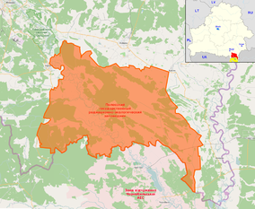
OSM map of the reserve highlighting some nearby places in the annotations (as Mazyr, Pripyat, the Chernobyl Plant etc). The map in the corner shows its position (red) within Belarus, showing also the Ukrainian, and contiguous, Chernobyl Exclusion Zone (yellow)
|
|
| Location of PSRER in Belarus | |
| Location |
|
| Nearest city | Brahin, Naroulia, Chojniki |
| Coordinates | 51°39′N 29°59′E / 51.650°N 29.983°ECoordinates: 51°39′N 29°59′E / 51.650°N 29.983°E |
| Area | 2162 km² |
| Established | 1988 |
| Official website | |
Polesie State Radioecological Reserve (Belarusian: Палескі дзяржаўны радыяцыйна-экалагічны запаведнік, Russian: Полесский государственный радиационно-экологический заповедник), is a nature reserve in Belarus, which was created to enclose the territory of Belarus most affected by radioactive fallout from the Chernobyl disaster. Also known as Zapovednik (Russian for "nature reserve"), it adjoins the Chernobyl Exclusion Zone in Ukraine. The environmental monitoring and countermeasure agency, Bellesrad, oversees the food cultivation and forestry in the area.
Two years after the Chernobyl disaster, the Belarusian part of the Chernobyl zone was extended to a more highly contaminated area. Then a closed nature reserve was established in Belarus with a total area of 1313 km². The reserve was established on July 18, 1988. Before the disaster, over 22,000 people lived there in 96 settlements. The population was evacuated after the disaster. In 1993 it was expanded by 849 km², making it the biggest Belarusian nature reserve and one of the biggest in Europe.
The area, located in southern Gomel Region and bordering the Ukrainian Exclusion Zone, includes part of the raions (districts) of Brahin, Chojniki and Naroulia. It is crossed by Pripyat River and the city of Mazyr is 36 km from the northwestern entrance at Naroulia. Its southern strip is crossed by the Chernihiv–Ovruch railway, that passes through the villages of Kaporanka, Kalyban and Pasudava.
...
Wikipedia

