Cherkassy Oblast
|
Cherkasy Oblast Черкаська область Cherkas’ka oblast’ |
|||
|---|---|---|---|
| Oblast | |||
|
|||
| Nickname(s): Черкащина (Cherkashchyna) | |||
 |
|||
| Country |
|
||
| Established | January 7, 1954 | ||
| Administrative center | Cherkasy | ||
| Largest cities | Cherkasy, Uman, Smila, Zolotonosha | ||
| Government | |||
| • Governor | Yuriy Tkachenko | ||
| • Oblast council | 76 seats | ||
| • Chairperson | Valentyna Kovalenko | ||
| Area | |||
| • Total | 20,900 km2 (8,100 sq mi) | ||
| Area rank | Ranked 18th | ||
| Population (2006) | |||
| • Total | 1,335,064 | ||
| • Rank | Ranked 15th | ||
| • Density | 64/km2 (170/sq mi) | ||
| Demographics | |||
| • Official language(s) | Ukrainian | ||
| • Average salary | UAH 817 (2006) | ||
| Time zone | EET (UTC+2) | ||
| • Summer (DST) | EEST (UTC+3) | ||
| Postal code | 18-20xxx | ||
| Area code | +380 47 | ||
| ISO 3166 code | UA-71 | ||
| Vehicle registration | CA | ||
| Raions | 20 | ||
| Cities (total) | 25 | ||
| • Regional cities | 6 | ||
| Urban-type settlements | 34 | ||
| Villages | 838 | ||
| FIPS 10-4 | UP01 | ||
| Website |
www.oda.ck.ua www.rada.gov.ua |
||
Cherkasy Oblast (Ukrainian: Черкаська область, translit. Cherkas’ka oblast’; also referred to as Черкащина, Cherkashchyna) is an oblast (province) of central Ukraine located along the Dnieper River. The administrative center of the oblast is the city of Cherkasy.
With 20,900 km², the Cherkasy oblast is the 18th largest oblast of Ukraine, comprising about 3.5% of the area of the country. The south flowing Dnieper River with the hilly western bank and the plain eastern bank divides the oblast into two unequal parts. The larger western part belongs to the Dnieper Upland. The low-lying eastern part of the oblast used to be subject to the frequent Dnieper flooding before the flow of the river became controlled by multiple dams of Hydroelectric Power Plants constructed along the river in the 20th century.
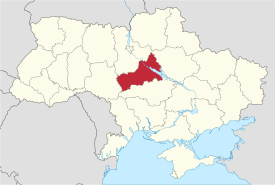
The oblast extends for 245 km from south-west to north-east, and for 150 km from north to south. The northernmost point of the oblast is located is near the village of Kononivka in the Drabivskyi Raion (district), the southernmost point near the village of Kolodyste in the Talnivskyi Raion, the westernmost point near the village of Korytnya in the Zhashkivskyi Raion, and the easternmost point near the village of Stetsivka in the Chyhyrynsky Raion. The geometric centre of the oblast is located near the village Zhuravky of the Horodyshchenskyi Raion. The oblast borders the Kiev Oblast to the north, the Kirovohrad Oblast to the south, the Poltava Oblast to the east, and the Vinnytsia Oblast to the west.
...
Wikipedia


