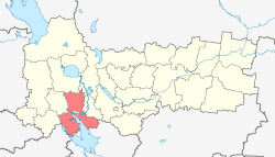
Cherepovetsky District
| Cherepovetsky District Череповецкий район (Russian) |
|
|---|---|
 Location of Cherepovetsky District in Vologda Oblast |
|
| Coordinates: 59°11′20″N 37°38′32″E / 59.18889°N 37.64222°ECoordinates: 59°11′20″N 37°38′32″E / 59.18889°N 37.64222°E | |
|
|
|
| Location | |
| Country | Russia |
| Federal subject | Vologda Oblast |
| Administrative structure (as of March 2012) | |
| Administrative center | city of Cherepovets |
| Administrative divisions: | |
| Selsoviets | 26 |
| Inhabited localities: | |
| Rural localities | 557 |
| Municipal structure (as of May 2013) | |
| Municipally incorporated as | Cherepovetsky Municipal District |
| Municipal divisions: | |
| Urban settlements | 0 |
| Rural settlements | 15 |
| Statistics | |
| Area | 7,640 km2 (2,950 sq mi) |
| Population (2010 Census) | 41,025 inhabitants |
| • Urban | 0% |
| • Rural | 100% |
| Density | 5.37/km2 (13.9/sq mi) |
| Time zone | MSK (UTC+03:00) |
| Established | August 1, 1927 |
| Official website | |
| on | |
Cherepovetsky District (Russian: Черепове́цкий райо́н) is an administrative and municipal district (raion), one of the twenty-six in Vologda Oblast, Russia. It is located in the northeast of the oblast and borders with Belozersky District in the north, Kirillovsky District in the northwest, Sheksninsky District in the east, Poshekhonsky District of Yaroslavl Oblast in the southeast, Breytovsky District of Yaroslavl Oblast in the south, Vesyegonsky District of Tver Oblast in the southwest, Ustyuzhensky District in the west, and with Kaduysky District in the northwest. The area of the district is 7,640 square kilometers (2,950 sq mi). Its administrative center is the city of Cherepovets (which is not administratively a part of the district). Population: 41,025 (2010 Census); 40,871 (2002 Census);48,336 (1989 Census).
The district is Y-shaped and oriented to the south, with the Rybinsk Reservoir separating the two southern portions of the land. The whole area of the district belongs to the basin of the Volga River. The eastern part belongs to the basin of the Sheksna River and to the basins of minor rivers flowing into the Rybinsk Reservoir. The lower course of the Sheksna crosses the area of the district, and the city of Cherepovets is located in the mouth of the river. The rivers in the western part drain mostly into the Suda and its tributaries, including the Andoga. The lower course of the Suda is also located in the district. The lower course of the Mologa forms the border between Cherepovetsky and Ustyuzhensky Districts. There are many lakes in the southwestern part of the district, the biggest being Lake Kolodenskoye.
...
Wikipedia


