Champlain River
| Champlain River | |
|
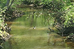
Champlain River in Trois-Rivières (Sector Saint-Louis-de-France)
|
|
| Country | |
|---|---|
| Province | |
| Region | Mauricie |
| Tributaries | |
| - left | Ruisseau Picardie, ruisseau des Prairies, Noire River (Champlain River), rivière au Lard, Brûlée River, ruisseau Barome, ruisseau Martin. |
| - right | Ruisseau des Plaines, ruisseau de la Racine Salée, cours d'eau Laborde, cours d'eau Clermont-Leblanc, cours d'eau Grandmont-Pintal, ruisseau de Rouille, ruisseau Pronovost, cours d'eau Normandin, ruisseau Beaudoin. |
| Source | Brook |
| - location | Saint-Maurice, Les Chenaux Regional County Municipality |
| - elevation | 59 m (194 ft) |
| - coordinates | 46°26′49″N 72°16′52″W / 46.44694°N 72.28111°W |
| Mouth | St Lawrence River |
| - location | Champlain, Mauricie administrative region |
| - elevation | 5 m (16 ft) |
| - coordinates | 46°26′49″N 72°16′55″W / 46.44694°N 72.28194°WCoordinates: 46°26′49″N 72°16′55″W / 46.44694°N 72.28194°W |
| Length | 66.7 km (41 mi) |
The Champlain River is 66.7 km long flowing on the north shore of St. Lawrence river. This river flows between Saint-Maurice River and the Batiscan River watershed, in Les Chenaux Regional County Municipality, in administrative region of Mauricie, in the province of Quebec, Canada.
Champlain River is flowing almost at the boundary between the manors of Batiscan and Champlain. Champlain river flows from north to south to empty in the St. Lawrence river at Champlain village. Champlain River rises at an altitude of about 130 meters in wetlands located at the foot of the moraine of Saint-Narcisse. Its watershed through the municipalities of Notre-Dame-du-Mont-Carmel, Trois-Rivières (Saint-Louis-de-France area), Saint-Maurice, Saint-Narcisse, Saint-Luc-de-Vincennes, Sainte-Geneviève-de-Batiscan, Batiscan and Champlain, all located, with the exception of Trois-Rivières, in the Les Chenaux Regional County Municipality.
...
Wikipedia

