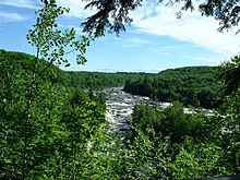
Batiscan River
| Batiscan River | |
|---|---|

"Chutes des Ailes" in Saint-Narcisse
|
|
| Country | Canada (Québec) |
| Basin features | |
| Main source |
Lac-Édouard, Quebec 363 m (1,191 ft) |
| River mouth | Saint Lawrence River at Batiscan |
| Basin size | 4,690 km2 (1,810 sq mi) |
| Physical characteristics | |
| Length | 196 km (122 mi) |
| Discharge |
|
The Batiscan River is located in La Mauricie administrative region, in the Quebec province, Canada. This river flows 196 km from Lake Édouard in Mauricie south and west to empty into the St. Lawrence River at Batiscan, Quebec, northeast of Trois-Rivières, Quebec. It passes through the regional county municipalities (RCM) (MRC in French) of La Tuque, Portneuf, Mékinac and Les Chenaux.
The river traverses a territory covered mainly by forest from its source to the Saint-Adelphe, Quebec railway bridge; the rest of its course is predominantly agricultural. The Batiscan river valley is designated "Batiscanie, Quebec". Today, this valley is a paradise for camping, vacationing, observations of nature and water activities such as canoeing, kayaking, rafting, pontoon and swimming in designated areas. The Batiscan River is a popular Canadian whitewater kayaking destination, providing numerous class III, IV, and V rapids.
The river was named in 1602 by Samuel de Champlain. He reported in 1610 that it was named for an Algonquin chief of the same name; however, this name was in use by Amerindian natives before the arrival of the first French explorers. The name "Batiscan" has been interpreted differently by various sources. Father Charles Arnaud argued that the name meant "steam cloud or light", or possibly "spray of dried meat". According to Pierre-Georges Roy the name means "who rushes to his mouth", which has been observed in the past. According to Father Albert Lacombe the name came from the Atikamekw term meaning "hoof or pending"; according to Father Joseph-Étienne Guinard, it derived from the cry "patiskam", meaning "stumble".
...
Wikipedia
