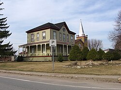
Saint-Luc-de-Vincennes, Quebec
| Saint-Luc-de-Vincennes | |
|---|---|
| Municipality | |
 |
|
 Location within Les Chenaux RCM. |
|
| Location in central Quebec. | |
| Coordinates: 46°30′N 72°25′W / 46.500°N 72.417°WCoordinates: 46°30′N 72°25′W / 46.500°N 72.417°W | |
| Country |
|
| Province |
|
| Region | Mauricie |
| RCM | Les Chenaux |
| Constituted | January 19, 1865 |
| Government | |
| • Mayor | Jean-Claude Milot |
| • Federal riding | Saint-Maurice—Champlain |
| • Prov. riding | Champlain |
| Area | |
| • Total | 54.20 km2 (20.93 sq mi) |
| • Land | 54.15 km2 (20.91 sq mi) |
| Population (2011) | |
| • Total | 591 |
| • Density | 10.9/km2 (28/sq mi) |
| • Pop 2006-2011 |
|
| • Dwellings | 273 |
| Time zone | EST (UTC−5) |
| • Summer (DST) | EDT (UTC−4) |
| Postal code(s) | G0X 3K0 |
| Area code(s) | 819 |
| Highways |
|
| Website | www devincennes |
Saint-Luc-de-Vincennes is a municipality in the Mauricie region of the province of Quebec in Canada. It is the seat of the RCM of Les Chenaux.
Population trend:
Private dwellings occupied by usual residents: 261 (total dwellings: 273)
Mother tongue:
...
Wikipedia

