Champlain (village), New York
| Champlain, New York | |
|---|---|
| Village | |
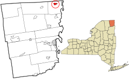
 Location in Clinton County and the state of New York. |
|
| Coordinates: 44°59′12″N 73°26′47″W / 44.98667°N 73.44639°WCoordinates: 44°59′12″N 73°26′47″W / 44.98667°N 73.44639°W | |
| Country | United States |
| State | New York |
| County | Clinton |
| Town | Champlain |
| Area | |
| • Total | 1.4 sq mi (3.7 km2) |
| • Land | 1.4 sq mi (3.6 km2) |
| • Water | 0.04 sq mi (0.1 km2) |
| Elevation | 105 ft (32 m) |
| Population (2010) | |
| • Total | 1,101 |
| • Density | 792/sq mi (305.9/km2) |
| Time zone | Eastern (EST) (UTC-5) |
| • Summer (DST) | EDT (UTC-4) |
| ZIP code | 12919 |
| Area code(s) | 518 |
| FIPS code | 36-13739 |
| GNIS feature ID | 0946361 |
| Website | www |
Champlain is a village in Clinton County, New York, United States. The population was 1,101 at the 2010 census. The village is located in the town of Champlain about 4 miles (6 km) west of Lake Champlain and is north of Plattsburgh.
The lake and the village were named in honor of Samuel de Champlain, who first surveyed the area in 1609. It was part of Canada until 1763, and became part of the United States in 1783.
Champlain was an important staging point in the War of 1812.
The village was incorporated in 1873.
Champlain village is located in the north-central part of the town of Champlain at 44°59′12″N 73°26′47″W / 44.986678°N 73.446373°W (44.986678, -73.446373).Interstate 87 (the Adirondack Northway) runs past the west side of the village, with access from exits 42 and 43. Montreal is 41 miles (66 km) to the north, and Plattsburgh is 22 miles (35 km) to the south. US 9 passes through the village and intersects US 11 south of the village. NY 276 intersects US-11 east of Champlain.
...
Wikipedia
