New York State Route 276
| New York State Route 276 | ||||
|---|---|---|---|---|

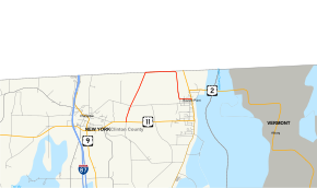
Map of Clinton County in northeastern New York with NY 276 highlighted in red
|
||||
| Route information | ||||
| Maintained by NYSDOT | ||||
| Length: | 4.69 mi (7.55 km) | |||
| Existed: | c. 1963 – present | |||
| Major junctions | ||||
| West end: |
|
|||
|
|
||||
| East end: |
|
|||
| Location | ||||
| Counties: | Clinton | |||
| Highway system | ||||
|
||||
New York State Route 276 (NY 276) is a state highway located entirely within Clinton County, New York, in the United States. It connects the town of Champlain to the village of Rouses Point, with both termini situated at intersections with U.S. Route 11 (US 11) about 5 miles (8 km) apart. The middle third of the route runs along the southern edge of the Canadian border and connects to Quebec Route 221 by way of the Overton Corners-Lacolle 221 Border Crossing midway between the villages of Champlain and Rouses Point. In Rouses Point, NY 276 is known as Church Street and Pratt Street. All of NY 276 was originally designated as part of NY 348 before gaining its current designation c. 1963.
NY 276 begins at an intersection with US 11 east of the village of Champlain in the town of the same name. The route heads northeast for 2 miles (3.2 km) through open fields to the Canadian border, where it intersects the de facto southern terminus of Quebec Route 221. Instead of continuing into Quebec, NY 276 turns east, running along the southern edge for the border for just over 1 mile (1.6 km) before turning south toward the village of Rouses Point. The amount of development along the route increases as it enters the village on Church Street.
...
Wikipedia

