Ceto, Lombardy
|
Ceto Hét |
|
|---|---|
| Comune | |
| Comune di Ceto | |

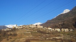
Ceto's panorama
|
|
 Comune of Ceto in Val Camonica |
|
| Location of Ceto in Italy | |
| Coordinates: 46°0′12″N 10°21′10″E / 46.00333°N 10.35278°ECoordinates: 46°0′12″N 10°21′10″E / 46.00333°N 10.35278°E | |
| Country | Italy |
| Region | Lombardy |
| Province / Metropolitan city | Province of Brescia (BS) |
| Frazioni | Badetto, Nadro |
| Area | |
| • Total | 32 km2 (12 sq mi) |
| Elevation | 453 m (1,486 ft) |
| Population (2011) | |
| • Total | 1,943 |
| • Density | 61/km2 (160/sq mi) |
| Demonym(s) | Cetesi |
| Time zone | CET (UTC+1) |
| • Summer (DST) | CEST (UTC+2) |
| Postal code | 25040 |
| Dialing code | 0364 |
| Patron saint | Sant'Andrea Apostolo |
| Saint day | 30 November |
| Website | Official website |
Ceto (Hét in local camunian dialect) is an Italian comune of 1943 inhabitants in Val Camonica, province of Brescia, in Lombardy.
The village of Ceto is bounded by other communes of Braone, Breno, Capo di Ponte, Cerveno, Cevo, Cimbergo, Daone (TN), Ono San Pietro.
In February 1798 the town of Nadro was united to that of Ceto, and assumed the name of "comune of Ceto and Nadro. "
Between 1816 and 1859 the town was called "Ceto with Nadro", while from 1859 to 1927 only "Ceto". In that year he was joined Cerveno, which was linked with the name "Ceto Cerveno" until 1947.
The churches of Ceto are:
The scütüm are in camunian dialect nicknames, sometimes personal, elsewhere showing the characteristic features of a community. The one which characterize the people of Ceto is Fontàne, Bagàtoi or Sgaréi.
...
Wikipedia

