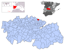
Carranque
| Carranque | |
|---|---|
| Municipality | |
 |
|
| Location in Spain | |
| Coordinates: 40°10′15″N 3°53′49″W / 40.17083°N 3.89694°WCoordinates: 40°10′15″N 3°53′49″W / 40.17083°N 3.89694°W | |
| Country |
|
| Autonomous community |
|
| Province | Toledo |
| Comarca | La Sagra |
| Judicial district | Illescas |
| Founded | Ver texto |
| Government | |
| • Alcalde | Alejandro Pompa de Mingo (2007) |
| Area | |
| • Total | 25 km2 (10 sq mi) |
| Elevation | 665 m (2,182 ft) |
| Population (2008) | |
| • Total | 3,591 |
| • Density | 140/km2 (370/sq mi) |
| Demonym(s) | Carranqueño, ña |
| Time zone | CET (UTC+1) |
| • Summer (DST) | CEST (UTC+2) |
| Postal code | 45216 |
| Dialing code | 925 |
| Website | Official website |
Carranque is a town in the Toledo province, Castile-La Mancha, Spain. It is located in the area of the province bordering the province of Madrid called the Alta Sagra.
Carranque contains the site of a Roman villa that is protected as an archeological park by the Castile-La Mancha government. There are three main buildings visible by above-ground remains, the ruins of a Roman mill and a modern interpretation building.
It is located by the River Guadarrama, near a Roman road. It seems to be near the lost city of Titultiam
The buildings date from the late fourth century and are thought to belong to a "Villa of Maternus Cinigius", the uncle of Theodosius. Theodosius I, Roman emperor, who was born in Hispania. In 1983 a local peasant, Samuel López Iglesias, found a series of mosaic floors while plowing in the fields known as las Suertes de Abajo.
The interpretation facility exhibits objects found during the excavations
A Theodosian-era building that takes as models the governors' palaces. The hall was surrounded with 32 monolithic marble columns from the emperor's private quarries in Chios in Greece (known as or chium) and Iscehisar and Afyon in Anatolia (phygium or pavonazzeto marble). Soon it was converted for use in Christian cult and burials. The Visigothic arrival brought some changes. It was also used during the Islamic age. The Knights Templar used it as an abbey or monastery.
It appears as the hermitage of Santa María de Batres in the Relaciones de Felipe II (1576), with most of the area used as a cemetery. It was used as such until the 17th century. The head of the Roman building, as the hermitage of Santa María de Abajo ("Saint Mary of the lower side"), lasted until around 1920 when it was dynamited to serve as construction material for the modern town.
...
Wikipedia

