Caraga Region
|
Caraga Caraga Administrative Region Region XIII |
||||||||
|---|---|---|---|---|---|---|---|---|
| Region | ||||||||
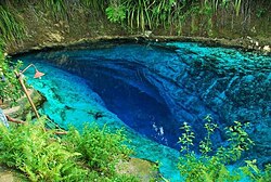
From top, left to right: A lagoon in Dinagat Islands; Tinuy-an Falls; Siargao Island; Macapagal Bridge in Butuan; Bayugan rotunda; Hinatuan Enchanted River
|
||||||||
 Location in the Philippines |
||||||||
| Coordinates: 8°55′N 125°30′E / 8.92°N 125.5°ECoordinates: 8°55′N 125°30′E / 8.92°N 125.5°E | ||||||||
| Country | Philippines | |||||||
| Island group | Mindanao | |||||||
| Regional center | Butuan | |||||||
| Area | ||||||||
| • Total | 21,478.35 km2 (8,292.84 sq mi) | |||||||
| Population (2015 census) | ||||||||
| • Total | 2,596,709 | |||||||
| • Density | 120/km2 (310/sq mi) | |||||||
| Time zone | PST (UTC+8) | |||||||
| ISO 3166 code | PH-13 | |||||||
| Provinces | ||||||||
| Cities | ||||||||
| Municipalities | 70 | |||||||
| Barangays | 1,310 | |||||||
| Cong. districts | 7 | |||||||
| Languages |
|
|||||||
Caraga, officially known as the Caraga Administrative Region or simply Caraga Region and designated as Region XIII, is an administrative region in the Philippines occupying the northeastern section of the island of Mindanao. The Caraga Region was created through Republic Act No. 7901 on February 23, 1995. The region comprises five provinces: Agusan del Norte, Agusan del Sur, Surigao del Norte, Surigao del Sur and Dinagat Islands; six cities: Butuan, Cabadbaran, Surigao City, Tandag, Bislig and Bayugan; 67 municipalities and 1,311 barangays. Butuan is the regional administrative center.
The etymology of Caraga is said to have originated from the native word Kalag which means "spirit of soul". Hence, the whole Provincia de Caraga of AD 1622 was called region de gente animosa, that is "region of spirited men". Another fictional etymology of the name flows from a local legend as coming from the word Cagang, a numerous small crabs matting the beach of Caraga, which is also known as katang to the native inhabitants. Legend goes that the town was named as such because the first Spanish missionaries who came in the early years of 1600 found numerous small crabs matting the beach.
During pre-colonial times, the Rajahnate of Butuan ruled in what is now Agusan del Norte and Butuan City. It had much influenced on all of Caraga, portions of Northern Mindanao, and western side of Bohol. According to records, Butuan was in a cordial relationship with the Sultanate of Ternate in the present-day Moluccas of Indonesia. The Ternateans would attack and ransack Butuan and its wealth, but Butuan always prevailed. It was known that the Rajahnate of Butuan had friendly relations with the Rajahnate of Cebu which it considered as an ally. The Rajahnate of Butuan became a powerful Hindu state which is much known for its goldsmithing and boat-making. The people of Butuan used gigantic boats known as balangay which carried numerous men. Relics of these gold crafts and giant boats have been unearthed and preserved by the National Museum of the Philippines and other international museums. Butuan also had cordial relations with the Kingdom of Champa in what is now central Vietnam. The Butuan people managed to traverse the Sulu Sea and the South China Sea to reach Champa for trade. While the Rajahnate of Butuan was at large, the indigenous lumads of the inner sections of Caraga were free and had their own democratic societies that were highly advanced. Their societies were known for their knowledge on nature, medicine, mythology, and warfare. Chinese traders eventually came into Butuan and the Sino-Butuan trade became the focal point of Champa-Butuan relations, where both nations were competing against each other to win favor of better trade with Chinese traders. Eventually, Butuan started to weaken due to massive attacks from Ternate. Cebu was unable to help at the time because it was also being attacked by Ternate. Likewise, the Kingdom of Dapitan in Bohol, "The Venice of the Visayas", was also destroyed by an attack from Ternate.
...
Wikipedia


