Capelo
| Capelo | |
| Civil Parish | |
|
The western landscape of Capelo, showing the Capelinhos Volcano, as it appeared (c.1990)
|
|
| Official name: Freguesia do Capelo | |
| Name origin: Portuguese for hood | |
| Country | |
|---|---|
| Autonomous Region | |
| Island | Faial |
| Municipality | Horta |
| Localities | Areeiro, Biscoitos, Canto, Cimo da Ribeira, Cruzeiro, Norte Pequeno, Ribeira do Cabo, Rua do Canto, Rua da Igreja, Varadouro |
| Landmark | Capelinhos |
| Center | Rua da Igreja |
| - elevation | 263 m (863 ft) |
| - coordinates | 38°35′8″N 28°47′52″W / 38.58556°N 28.79778°WCoordinates: 38°35′8″N 28°47′52″W / 38.58556°N 28.79778°W |
| Highest point | |
| - location | Caldeira, Lomba do Meio |
| - elevation | 1,015 m (3,330 ft) |
| - coordinates | 38°34′42″N 28°43′22″W / 38.57833°N 28.72278°W |
| Lowest point | Sea level |
| - location | Atlantic Ocean |
| - elevation | 0 m (0 ft) |
| Area | 26.64 km2 (10 sq mi) |
| - urban | .93 km2 (0 sq mi) |
| Population | 486 (2011) |
| Density | 18/km2 (47/sq mi) |
| Settlement | fl. 1550 |
| - Civil Parish | c. 1600 |
| LAU | Junta Freguesia |
| - location | Rua da Igreja |
| President Junta | Ana Paula da Silva Oliveira |
| President Assembleia | Filomena Teresinha Pereira Serpa |
| Timezone | Azores (UTC-1) |
| - summer (DST) | Azores (UTC0) |
| Postal Zone | 9900-302 |
| Area Code & Prefix | (+351) 292 XXX-XXXX |
| Demonym | Capelense |
| Patron Saint | Santissima Trinidade |
|
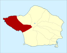
Location of the civil parish of Capelo within the municipality of Horta
|
|
Capelo is a civil parish in the municipality of Horta on the island of Faial in the Azorean archipelago. The population in 2011 was 486, in an area of 26.64 km².
The village was elevated to civil parish in 1600, when it was de-annexed from the neighbouring parish of Praia do Norte. Friar Diogo das Chagas, in 1643, noted that the parish had about 160 inhabitants, and approximately 44 residences. At its largest, the population reached 1,400 inhabitants.
The town was practically destroyed in 1672 and 1673 during the volcanic eruption of Cabeço de Fogo (the name of the central volcano on the island of Faial). During this eruption, volcanic ash and pyroclastic projectiles rained down on the community, destroying homes and sterilizing agricultural lands in Capelo and Praia do Norte. Ironically, between 1673 and 1845, Praia do Norte was integrated into the civil parish of Capelo.
The Church of the Santissima Trinidade (Church of the Holy Trinity) in Capelo, was ordered constructed by the Captain-major, Jorge Goulart Pimental, to replace the parochial church, the Chapel of Nossa Senhora da Esperança (Our Lady of Hope), which was destroyed during the 1672 volcanic eruption. A chapel to Nossa Senhora da Esperança was later constructed near the old church (which has since disappeared from the landscape).
The chapel of Varadouro was founded in 1720, by Father Manuel Pereira Cardoso, to the invocation of Nossa Senhora do Carmo (Our Lady of Mount Carmel). Later, in his 1725 last testament, Father Cardoso requested that his inheritors celebrate a mass in perpetuity to the name Nossa Senhora do Carmo, the Holy Sacrament, and Santo António, on every first Sunday of October. The spa at Varadouro was constructed and inaugurated on 1 August 1954 by architect Read Teixeira.
Mountainous volcanic craters cover the majority of the parish (being the location of the most recent volcanic eruption in the Azores). The parish has several facets: an area of volcanic craters that extends from the islands caldera, inland pasturelands used to support the agricultural/dairy industry, and a coastal zone of cottages and oceanfront pools. Linking these areas is the ubiquitous Regional Road E.R. 1-1ª that connects the communities on the island with Horta in the southeast corner.
...
Wikipedia


