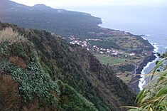
Praia do Norte
| Praia do Norte | |
| Civil Parish | |
|
The overlook from Ribeira Funda, with the parish of Praia do Norte, and the coastal community of Fajã
|
|
| Official name: Freguesia da Praia do Norte | |
| Name origin: Portuguese for "north beach" | |
| Country | |
|---|---|
| Autonomous Region | |
| Island | Faial |
| Municipality | Horta |
| Localities | Cerca, Fajã, Praia do Norte |
| Rivers | Ribeira das Cabras, Ribeira do Adão, Ribeira do Bom Dia, Ribeira do Serrado Novo, Ribeira Funda |
| Center | Praia do Norte |
| - elevation | 191 m (627 ft) |
| - coordinates | 38°36′14″N 28°45′32″W / 38.60389°N 28.75889°WCoordinates: 38°36′14″N 28°45′32″W / 38.60389°N 28.75889°W |
| Highest point | Alto do Brejo |
| - location | Cabeço Gordo |
| - elevation | 926 m (3,038 ft) |
| - coordinates | 38°35′28″N 28°43′30″W / 38.59111°N 28.72500°W |
| Lowest point | Sea level |
| - location | Atlantic Ocean |
| - elevation | 0 m (0 ft) |
| Area | 13.85 km2 (5 sq mi) |
| - urban | .28 km2 (0 sq mi) |
| Population | 250 (2011) |
| Density | 18/km2 (47/sq mi) |
| Settlement | fl. 30 June 1567 |
| - Parish | fl. 1787 |
| - Civil Parish | 1 October 1845 |
| LAU | Junta Freguesia |
| - location | Largo da Igreja |
| President Junta | Estevão Gomes |
| President Assembleia | Tomás Américo Silveira Correia |
| Timezone | Azores (UTC-1) |
| - summer (DST) | Azores (UTC0) |
| Postal Zone | 9900-473 |
| Area Code & Prefix | (+351) 292 XXX-XXXX |
| Patron Saint | Nossa Senhora das Dores |
|
Location of the civil parish of Praia do Norte within the municipality of Horta
|
|
| Website: http://www.jf-praiadonorte.com | |
Praia do Norte is a civil parish of the municipality of Horta, located along the northern coast between Cedros and Capelo, on the Portuguese island of Faial, in the archipelago of the Azores. The population in 2011 was 250, in an area of 13.85 square kilometres (5.35 sq mi). It is the least populous parish on the island, reached along the Estrada Regional E.R.1-1ª regional roadway from the urban centre of Horta.
This parish, and its church, were first referenced on 30 June 1567, for its fertile soil (which produced many of the islands cereals, beans and fruits). By 1643, there were 274 inhabitants and 77 homes in the area (as referenced by Diogo das Chagas). The parish at one time included the region of Capelo, but it was de-annexed.
The primitive parochial church was destroyed completely by the eruption of Cabeço do Fogo in 1672. At about one in the morning, a violent explosion awoke many of the residents, and forced them from their homes. Two lava flows escaped Cabeço do Fogo towards the north (Praia do Norte) and south (destroying the community of Ribeira do Cabo in Capelo). The northern flow, after pausing to destroy Lameiros, reached Praia do Norte where it covered the parish in black rock, covering the large tracts of arable land. Many of the residents of the northern coast abandoned the area, eventually resulting in the parish being incorporated into the neighboring parish (Capelo). According to Américo Costa (in Dicionário Corográfico) a large part of the inhabitants of both parishes (Capelo and Praia do Norte) were affected by the eruption; homes and farmlands in Ribeira do Cabo (Capelo), Lameiros and Praia do Norte were destroyed. A niche, located at the intersection to Norte Pequeno, currently marks the position of the old church. Some inhabitants returned gradually, planting vineyards and fruit trees and small agricultural farming developed on the higher elevations.
By the beginning of the 18th century 712 inhabitants lived in 180 buildings in the parish. In 1787, a chapel of Nossa Senhora de Penha de França was erected by the Madalena-native José Nunes da Silveira in Fajã da Praia. Another chapel, consecrated in the name of Nossa Senhora das Dores, was constructed in 1797.
Its civil parish status was returned on 1 October 1845, in its entirety. Celebrations marking these circumstances were only realized in 1845.
...
Wikipedia


