Cape de Verde
|
Republic of Cabo Verde
República de Cabo Verde (Portuguese)
|
|||||
|---|---|---|---|---|---|
|
|||||

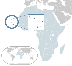
Location of Cape Verde (dark blue)
– in Africa (light blue & dark grey) |
|||||
| Capital and largest city |
Praia 14°55′N 23°31′W / 14.917°N 23.517°W |
||||
| Official languages | Portuguese | ||||
| Recognised national languages | Cape Verdean Creole | ||||
| Ethnic groups | Mixed-race 80% Black ~17% White ~3% |
||||
| Demonym | Cape Verdean or Cabo Verdean | ||||
| Government | Unitary semi-presidential republic | ||||
| Jorge Carlos Fonseca | |||||
| Ulisses Correia e Silva | |||||
| Legislature | National Assembly | ||||
| Independence | |||||
|
• from Portugal
|
5 July 1975 | ||||
| Area | |||||
|
• Total
|
4,033 km2 (1,557 sq mi) (172nd) | ||||
|
• Water (%)
|
negligible | ||||
| Population | |||||
|
• 2015 estimate
|
525,000 (167th) | ||||
|
• Density
|
123.7/km2 (320.4/sq mi) (89th) | ||||
| GDP (PPP) | 2016 estimate | ||||
|
• Total
|
$3.649 billion | ||||
|
• Per capita
|
$6,867 | ||||
| GDP (nominal) | 2016 estimate | ||||
|
• Total
|
$1.747 billion | ||||
|
• Per capita
|
$3,287 | ||||
| Gini (2008) | 47.2 high |
||||
| HDI (2015) |
medium · 122nd |
||||
| Currency | Cape Verdean escudo (CVE) | ||||
| Time zone | CVT (UTC-1) | ||||
|
• Summer (DST)
|
not observed (UTC-1) | ||||
| Drives on the | right | ||||
| Calling code | +238 | ||||
| ISO 3166 code | CV | ||||
| Internet TLD | .cv | ||||
– in Africa (light blue & dark grey)
– in the African Union (light blue)
Cape Verde /ˌkeɪp ˈvɜːrd/ or Cabo Verde /kɑːboʊ ˈvɜːrdeɪ/, /kæ-/ (Portuguese: Cabo Verde, pronounced: [ˈkabu ˈveɾdɨ]), officially the Republic of Cabo Verde, is an island country spanning an archipelago of 10 volcanic islands in the central Atlantic Ocean. Located 570 kilometres (350 mi) off the coast of West Africa, the islands cover a combined area of slightly over 4,000 square kilometres (1,500 sq mi).
...
Wikipedia


