Cape Blanc

|
|
| Geography | |
|---|---|
| Location | Africa |
| Coordinates | 20°46′17″N 17°2′50″W / 20.77139°N 17.04722°WCoordinates: 20°46′17″N 17°2′50″W / 20.77139°N 17.04722°W |
| Adjacent bodies of water | |
| Length | 60 km (37 mi) |
| Width | 12 km (7.5 mi) |
| Administration | |
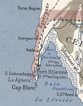
Ras Nouadhibou (Arabic: رأس نواذيبو) is a 40-mile peninsula or headland divided between Mauritania and Western Sahara on the African coast of the Atlantic Ocean. It is internationally known as Cabo Blanco in Spanish or Cap Blanc in French (both meaning "White Headland").
In the 14th and 15th centuries, fishing activities carried out from the nearby Canary Islands, by Spanish fishermen, inspired Spain to develop an interest in the desert coast of what is today called Western Sahara.
Cabo Blanco, in the Atlantic Ocean, is the only place in the world where Mediterranean monk seals form a true colony. In 1997, two-thirds of the colony died off, but there has been gradual recovery since.
The headland forms the western limit of Dakhlet Nouadhibou Bay.
This thin stretch of land is divided between Mauritania and Western Sahara. On the western side lies the ghost town of La Guera; on the eastern side, less than a mile from the border, lies Mauritania's Nouadhibou (formerly Port Etienne). The Tropic of Cancer runs through the peninsula.
Portuguese sailing explorers first reached the location they called Cabo Branco in 1441. The Spanish interest in Western Africa, in the desert coast of the Sahara, resulted from fishing activities carried out from the Canary Islands by Spanish fishermen, who also hunted and traded seal. The Spanish fished and whaled off the Sahara coast from Dakhla to Ras Nouadhibou from 1500 to the present, ranging from whaling humpback whales and likely North Atlantic right whales and whale calves, mostly in Cape Verde, the Guinea gulf in Annobon, and the São Tomé and Príncipe islands. These fishing activities have had a negative impact on wildlife and caused the disappearance or endangerment of many species of marine mammals and birds.
...
Wikipedia

