Nouadhibou
|
Nouadhibou نواذيبو |
|
|---|---|
| Commune and town | |

A street in Nouadhibou
|
|
| Location in Mauritania | |
| Coordinates: 20°56′N 17°2′W / 20.933°N 17.033°WCoordinates: 20°56′N 17°2′W / 20.933°N 17.033°W | |
| Country |
|
| Region | Dakhlet Nouadhibou Region |
| Elevation | 0 m (0 ft) |
| Population (2013 census) | |
| • Total | 118,167 |
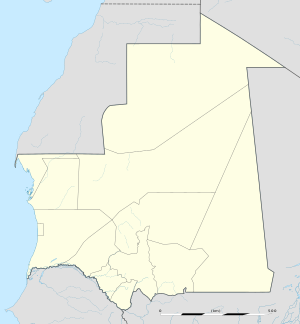
Nouadhibou (Arabic: نواذيبو; formerly Port-Étienne) is the second largest city in Mauritania and serves as a major commercial centre. The city itself has about 118,000 inhabitants expanding to over 140,000 in the larger metropolitan area, a total of nearly 95% of the entire regional population and is the country's economic capital. It is situated on a 65-kilometre peninsula or headland called Ras Nouadhibou, Cap Blanc, or Cabo Blanco, of which the western side, with the city of La Güera, is part of Western Sahara. Nouadhibou is consequently located merely a couple of kilometers from the border between Mauritania and Western Sahara. Its current mayor is Mohamed Fadel ould Aboubekrine.
The city is divided into four major areas: the city centre, including the airport; Numerowatt to the north; Cansado, the main residential area, to the south; and a dormitory town for Port Minéralier in the far south, from which iron ore mined in Zouerat is exported.
Attractions in Nouadibou include the Table Remarquable, several markets, a ships' graveyard and Mediterranean monk seals.
The port of Nouadhibou is the final resting place of over 300 ships and hence the world’s largest ship graveyard. Unlike the arrival en masse of ships at Mallows Bay, here the number of craft has built up over time, as corrupt officials accepted bribes from boat owners to allow them to dump their vessels in the area.
...
Wikipedia

