Canton, Massachusetts
| Canton, Massachusetts | ||
|---|---|---|
| Town | ||

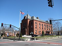
Town Hall
|
||
|
||
 Location in Norfolk County in Massachusetts |
||
| Coordinates: 42°09′30″N 71°08′43″W / 42.15833°N 71.14528°W | ||
| Country | United States | |
| State | Massachusetts | |
| County | Norfolk | |
| Settled | 1630 | |
| Incorporated | 1797 | |
| Government | ||
| • Type | Open town meeting | |
| Area | ||
| • Total | 19.6 sq mi (50.7 km2) | |
| • Land | 18.9 sq mi (49.0 km2) | |
| • Water | 0.6 sq mi (1.7 km2) | |
| Elevation | 100 ft (30 m) | |
| Population (2010) | ||
| • Total | 21,561 | |
| • Density | 1,140.8/sq mi (440.0/km2) | |
| Time zone | Eastern (UTC−5) | |
| • Summer (DST) | Eastern (UTC−4) | |
| ZIP Code | 02021 | |
| Area code(s) | 781/339 | |
| FIPS code | 25-11315 | |
| GNIS feature ID | 0619457 | |
| Website | www.town.canton.ma.us | |
Canton is a town in Norfolk County, Massachusetts, United States. The population was 21,561 at the 2010 census. Canton is part of Greater Boston, about 15 miles (24 kilometers) southwest of downtown Boston.
Canton was officially incorporated on February 23, 1797 from the town of Stoughton, Massachusetts. The name "Canton" was suggested by Elijah Dunbar and comes from the early belief that Canton, China was on the complete opposite side of the earth (antipodal). In addition to being a prominent Canton citizen, Elijah Dunbar was the first president of the Stoughton Musical Society from 1786 to 1808. Now named the Old Stoughton Music Society, it is the oldest choral society in the United States.
Paul Revere built the nation's first copper rolling mill in Canton in 1801. His poem entitled Canton Dale expresses his affection for the town. Canton was the location of the Rising Sun Stove Polish Company, founded by Elijah Morse, a wealthy merchant and creator of the pot-belly stove.
Canton is the headquarters of Reebok, Dunkin' Donuts, Computershare (North American HQ), Organogenesis, Inc., Interpolymer Corporation, Casual Male Retail Group, and formerly, Tweeter. It is also home to the Massachusetts Division headquarters of the Salvation Army.
According to the Town's 2011 Comprehensive Annual Financial Report, the top employers in the city are:
According to the United States Census Bureau, the town has a total area of 19.6 square miles (51 km2), of which, 18.9 square miles (49 km2) of it is land and 0.6 square miles (1.6 km2) of it (3.27%) is water.
Canton lies at the foot of Great Blue Hill. The Canton River flows through the center of the town, linking a chain of small lakes including Bolivar and Forge Ponds and flowing into the Neponset River. The Neponset River forms the boundary between Canton and its western neighbors: Norwood, Westwood, and Dedham. In addition to wooded land, the area includes wetlands, particularly in the eastern part along Route 138 near the Randolph and Stoughton borders, and in the western part along I-95.
...
Wikipedia

