Westwood, Massachusetts
| Westwood, Massachusetts | ||
|---|---|---|
| Town | ||

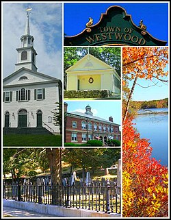
From left to right: Westwood First Parish Church, inscription on town clock, Fisher School House, Hale Reservation, Town Hall, and the Old Burial Ground
|
||
|
||
| Motto: "Committed to service" | ||
 Location in Norfolk County in Massachusetts |
||
| Coordinates: 42°12′50″N 71°13′30″W / 42.21389°N 71.22500°WCoordinates: 42°12′50″N 71°13′30″W / 42.21389°N 71.22500°W | ||
| Country | United States | |
| State | Massachusetts | |
| County | Norfolk | |
| Settled | 1640 | |
| Incorporated | 1897 | |
| Government | ||
| • Type | Open town meeting | |
| Area | ||
| • Total | 11.1 sq mi (28.8 km2) | |
| • Land | 11.0 sq mi (28.4 km2) | |
| • Water | 0.2 sq mi (0.4 km2) | |
| Elevation | 220 ft (67 m) | |
| Population (2010) | ||
| • Total | 14,618 | |
| • Density | 1,328.9/sq mi (514.7/km2) | |
| Time zone | Eastern (UTC-5) | |
| • Summer (DST) | Eastern (UTC-4) | |
| ZIP code | 02090 | |
| Area code(s) | 339 / 781 | |
| FIPS code | 25-78690 | |
| GNIS feature ID | 0618333 | |
| Website | www.townhall.westwood.ma.us | |
Westwood is a town in Norfolk County, Massachusetts, United States. The population was 14,618 at the 2010 census. In July 2005, CNN/Money and Money magazine ranked Westwood 13th on its list of the 100 Best Places to Live in the United States. Boston Magazine included Gay Street in Westwood on its list of the Best Streets in the Boston area. It is currently the 16th wealthiest town in Massachusetts.
Westwood was first settled in 1641 and was part of the town of Dedham, originally called 'West Dedham', until it was officially incorporated in 1897. It was the last town to split from the original town of Dedham.
It was originally to have been named the "Town of Nahatan:"
It was desirable for the old, as well as the new town, to have the question of incorporation settled, if possible, before April 5, when appropriations for the coming year were going to be made. Therefore, in order to remove every trace of friction, however trivial, and thus expedite matters, the name was changed to Westwood.
In July 2005, CNN/Money and Money magazine ranked Westwood 13th on its list of the 100 Best Places to Live in the United States. Boston Magazine listed Gay Street in Westwood on its list of the Best Streets in the Boston area.
According to the United States Census Bureau, the town has a total area of 11.1 square miles (29 km2), of which, 11.0 square miles (28 km2) of it is land and 0.2 square miles (0.52 km2) of it (1.35%) is water.
Westwood is located in eastern Massachusetts, bordered by:
As of the census of 2000, there were 14,117 people, 5,122 households and 3,867 families residing in the town. The population density was 1,286.7 people per square mile (496.9/km²). There were 5,251 housing units at an average density of 478.6/sq mi (184.8/km²). The racial makeup of the town was 95.98% White, 0.50% African American, 0.04% Native American, 2.48% Asian, 0.21% from other races, and 0.79% from two or more races. Hispanic or Latino of any race were 0.94% of the population.
...
Wikipedia

