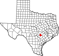
Caldwell County, Texas
| Caldwell County, Texas | |
|---|---|

The Caldwell County Courthouse in Lockhart
|
|
 Location in the U.S. state of Texas |
|
 Texas's location in the U.S. |
|
| Founded | 1848 |
| Named for | Mathew Caldwell |
| Seat | Lockhart |
| Largest city | Lockhart |
| Area | |
| • Total | 547 sq mi (1,417 km2) |
| • Land | 545 sq mi (1,412 km2) |
| • Water | 1.9 sq mi (5 km2), 0.3% |
| Population | |
| • (2010) | 38,066 |
| • Density | 70/sq mi (27/km²) |
| Congressional districts | 27th, 35th |
| Time zone | Central: UTC-6/-5 |
| Website | co |
Caldwell County is a county located in the U.S. state of Texas. As of the 2010 census, the population was 38,066. Its county seat is Lockhart. The county was founded in 1848 and was named after Mathew Caldwell, a ranger captain who fought in the Battle of Plum Creek against the Comanches and against Santa Anna's armies during the Texas Revolution. Caldwell was also a signer of the Texas Declaration of Independence.
Caldwell County is part of the Greater Austin metropolitan area.
According to the U.S. Census Bureau, the county has a total area of 547 square miles (1,420 km2), of which 545 square miles (1,410 km2) is land and 1.9 square miles (4.9 km2) (0.3%) is water.
As of the 2010 United States Census, there were 38,066 people residing in the county. 75.8% were White, 6.8% Black or African, 0.9% Asian, 0.8% Native American, 13.1% of some other race and 2.5% of two or more races. 47.1% were Hispanic or Latino (of any race).
As of the census of 2000, there were 32,194 people, 10,816 households, and 8,079 families residing in the county. The population density was 59 people per square mile (23/km²). There were 11,901 housing units at an average density of 22 per square mile (8/km²). The racial makeup of the county was 70.13% White, 8.50% Black or African American, 0.61% Native American, 0.34% Asian, 0.03% Pacific Islander, 17.66% from other races, and 2.74% from two or more races. 40.44% of the population were Hispanic or Latino of any race.
...
Wikipedia
