Calais
| Calais | |||
|---|---|---|---|

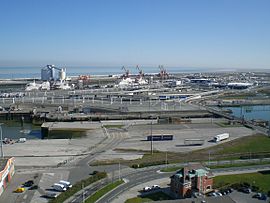
Port of Calais
|
|||
|
|||
| Coordinates: 50°56′53″N 1°51′23″E / 50.9480555555556°N 1.8563888888889°ECoordinates: 50°56′53″N 1°51′23″E / 50.9480555555556°N 1.8563888888889°E | |||
| Country | France | ||
| Region | Hauts-de-France | ||
| Department | Pas-de-Calais | ||
| Arrondissement | Calais | ||
| Intercommunality | Communauté d'agglomération du Calaisis | ||
| Government | |||
| • Mayor (2014–2020) | Natacha Bouchart (LP) | ||
| Area1 | 33.5 km2 (12.9 sq mi) | ||
| Population (2012)2 | 72,589 | ||
| • Density | 2,200/km2 (5,600/sq mi) | ||
| Demonym(s) | Calaisiens | ||
| Time zone | CET (UTC+01) (UTC+1) | ||
| • Summer (DST) | CEST (UTC+2) | ||
| INSEE/Postal code | 62193 / 62100 | ||
| Elevation | 0–18 m (0–59 ft) | ||
| Website | Town; Port | ||
|
1 French Land Register data, which excludes lakes, ponds, glaciers > 1 km² (0.386 sq mi or 247 acres) and river estuaries. 2Population without double counting: residents of multiple communes (e.g., students and military personnel) only counted once. |
|||
1 French Land Register data, which excludes lakes, ponds, glaciers > 1 km² (0.386 sq mi or 247 acres) and river estuaries.
Calais (/ˈkæleɪ/ CAL-ay, traditionally /ˈkælᵻs/; French pronunciation: [kalɛ]; Picard: Calés; Dutch: Kales) is a town and major ferry port in northern France in the department of Pas-de-Calais, of which it is a sub-prefecture. Although Calais is by far the largest city in Pas-de-Calais, the department's prefecture is its third-largest city of Arras. The population of the metropolitan area at the 2010 census was 126,395. Calais overlooks the Strait of Dover, the narrowest point in the English Channel, which is only 34 km (21 mi) wide here, and is the closest French town to England. The White Cliffs of Dover can easily be seen on a clear day from Calais. Calais is a major port for ferries between France and England, and since 1994, the Channel Tunnel has linked nearby Coquelles to Folkestone by rail.
...
Wikipedia


