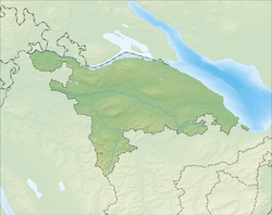
Bussnang
| Bussnang | ||
|---|---|---|
 |
||
|
||
| Coordinates: 47°33′N 9°4′E / 47.550°N 9.067°ECoordinates: 47°33′N 9°4′E / 47.550°N 9.067°E | ||
| Country | Switzerland | |
| Canton | Thurgau | |
| District | Weinfelden | |
| Area | ||
| • Total | 18.91 km2 (7.30 sq mi) | |
| Elevation | 445 m (1,460 ft) | |
| Population (Dec 2015) | ||
| • Total | 2,264 | |
| • Density | 120/km2 (310/sq mi) | |
| Postal code | 9565 | |
| SFOS number | 4921 | |
| Surrounded by | Affeltrangen, Amlikon-Bissegg, Braunau, Bürglen, Schönholzerswilen, Weinfelden | |
| Website |
www SFSO statistics |
|
Bussnang is a municipality in the district of Weinfelden in the canton of Thurgau in Switzerland.
Bussnang may be first mentioned in 822 as Pussinwanc. During the Early Middle Ages, the Abbey of St. Gall owned much of the land around Bussnang. During the High Middle Ages, the Baron of Bussnang ruled over the village. Starting in 1443, it became part of the Herrschaft of Weinfelden in the low court of Bussnang-Rothenhausen.
The Gallus Church was founded in 885, and in 1123 it was dedicated to John the Baptist. The right to appoint the priest was held by the Baron until 1464, when it went to the Commandry of Tobel. This right remained in Tobel until 1809, when it went to the canton of Thurgau, followed by the municipality in 1830. Originally the parish included the area of the later parishes of Wertbühl (created in 1155) and Weinfelden (created in 1275). In the Late Middle Ages, the parish stretched out over nine lower courts. The chapel at Schönholzerswilen was a filial church of Bussnang. In 1529, the parish was converted to the Reformation by Johannes Zwick, though mass was re-instituted in 1596. The village church remained a shared church until 1935 when the Catholic Rundkirche was finished. The sectarian clashes were relieved but not settled with the so-called Rosenbach'schen Treaty of 1639.
In 124 AD a Roman bridge was built over the Thur. Later, a ferry operated until 1453 when a bridge was built in Thurrain (part of Rothenhausen). However, through the following centuries traffic remained light and the village experienced little economic growth. In 1882, the Ganggelisteg bridge was built. It was exclusively for pedestrians and brought only limited economic improvement. Since 1912-13 a viaduct of the Mittel-Thurgau-Bahn rail line, has spanned the Furtbach valley. Originally, the main economic activities were grain cultivation in a three-field system and some vineyards. In the 19th Century this shifted to cattle and dairy farming and fruit cultivation. Most of the commercial activity was in linen and cotton weaving, and later handicrafts. Since 1963, Stadler Fahrzeuge AG produces their electric railway .
...
Wikipedia


