Braunau, Switzerland
| Braunau | ||
|---|---|---|

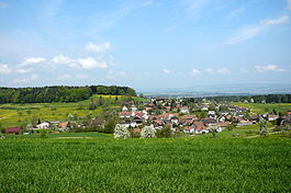
Braunau village
|
||
|
||
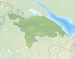
| Coordinates: 47°30′N 9°4′E / 47.500°N 9.067°ECoordinates: 47°30′N 9°4′E / 47.500°N 9.067°E | ||
| Country | Switzerland | |
| Canton | Thurgau | |
| District | Münchwilen | |
| Area | ||
| • Total | 9.17 km2 (3.54 sq mi) | |
| Elevation | 670 m (2,200 ft) | |
| Population (Dec 2015) | ||
| • Total | 760 | |
| • Density | 83/km2 (210/sq mi) | |
| Postal code | 9502 | |
| SFOS number | 4723 | |
| Surrounded by | Affeltrangen, Bronschhofen (SG), Bussnang, Schönholzerswilen, Tobel-Tägerschen, Wuppenau | |
| Website |
www SFSO statistics |
|
Braunau is a municipality in the district of Münchwilen in the canton of Thurgau in Switzerland.
Braunau is first mentioned in 762 as Pramacunauia, when it was owned by the Abbey of St. Gall. It was acquired when the Abbey acquired land in the Toggenburg. Initially it was ruled as a fief of the Abbey by the Heitnau family, until 1228 when it went to the Knights Hospitaller Commandry of Tobel. It was under their rule until 1798.
Originally, it was part of the Affeltrangen parish, however, St. Michael's Chapel, belonged to the Märwil parish at sometime before 1228. In 1529, most of the population converted during the Protestant Reformation. The remaining Catholics became part of the Tobel parish, while the Reformed members joined the Märwil parish. In 1806-07 a church was constructed, and in 1810 the village separated from Märwil. In 1861 it formed an independent parish.
The regulations (German: Offnung) of 1519 regulated the daily life in the village. Grain was grown in a three-field system. Starting in the mid-19th Century, cattle and dairy farming with cheese production and fruit production became common. In the early 19th Century cotton and linen weaving entered the village as a cottage industry. Since about 1895 timber industry has been in the village with some carpentry and a sawmill.
Until 1998 it was part of the municipality of Tobel.
Braunau has an area, as of 2009[update], of 9.17 square kilometers (3.54 sq mi). Of this area, 6.29 km2 (2.43 sq mi) or 68.6% is used for agricultural purposes, while 2.31 km2 (0.89 sq mi) or 25.2% is forested. Of the rest of the land, 0.57 km2 (0.22 sq mi) or 6.2% is settled (buildings or roads) and 0.02 km2 (4.9 acres) or 0.2% is unproductive land.
...
Wikipedia


