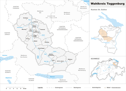
Toggenburg
|
Toggenburg Wahlkreis Toggenburg |
|
|---|---|
| constituency, geographical region | |
 |
|
| Coordinates: 47°17′58″N 9°5′13″E / 47.29944°N 9.08694°ECoordinates: 47°17′58″N 9°5′13″E / 47.29944°N 9.08694°E | |
| Country |
|
| Canton |
|
| Area | |
| • Total | 488.75 km2 (188.71 sq mi) |
| Population (December 2015) | |
| • Total | 45,912 |
| • Density | 94/km2 (240/sq mi) |
| Time zone | CET (UTC+1) |
| • Summer (DST) | CEST (UTC+2) |
| Municipalities | 12 |
Toggenburg is a region of Switzerland. It corresponds to the upper valley of the river Thur and that of its main tributary, the Necker. Since 1 January 2003, Toggenburg has been a constituency (Wahlkreis) of the canton of St. Gallen (SFOS number 1727).
The valley descends in a northwestern direction from the watershed between the Rhine and the Thur, and is enclosed on the northeast by the chain of the Säntis (8,216 ft [2,504 m]) and on the southwest by that of the Churfirsten (7,566 ft [2,306 m]) and of the Speer (6,411 ft [1,954 m]). It is a fertile valley of about 45 kilometres (28 mi) in length from the source of the river to Wil on the railway line between Winterthur and St. Gallen. The upper half is traversed by an excellent road, while from Nesslau there is a railway to Wil (155 m [509 ft]).
At Wildhaus, the highest village (3,632 ft [1,107 m]), the house wherein Huldrych Zwingli, the Swiss Reformer, was born in 1484, is still shown. Other villages are Lichtensteig, Kirchberg and Wattwil.
There are traces of the paleolithic Mousterian Industry throughout the Appenzell Alps, in the Toggenburg notably in Wildenmannlisloch cave.
The upper Thur valley was part of the province of Raetia in the Roman era, and was reached by Alemannic-speaking settlers only in the early medieval period. This is evidenced by a substantial substrate of Romance toponyms in the upper Toggenburg (upstream of Stein).
...
Wikipedia
