Burkesville
| Burkesville, Kentucky | |
|---|---|
| City | |

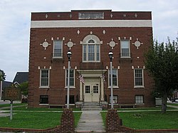
Cumberland County courthouse in Burkesville
|
|
 Location of Burkesville in Cumberland County, Kentucky. |
|
| Coordinates: 36°47′34″N 085°22′10″W / 36.79278°N 85.36944°WCoordinates: 36°47′34″N 085°22′10″W / 36.79278°N 85.36944°W | |
| Country | United States |
| State | Kentucky |
| County | Cumberland |
| Government | |
| • Mayor | Keith Riddle |
| Area | |
| • Total | 2.64 sq mi (6.85 km2) |
| • Land | 2.57 sq mi (6.65 km2) |
| • Water | 0.08 sq mi (0.20 km2) |
| Elevation | 581 ft (177 m) |
| Population (2010) | |
| • Total | 1,521 |
| • Estimate (2016) | 1,509 |
| • Density | 592/sq mi (228.7/km2) |
| Time zone | CST (UTC-5) |
| • Summer (DST) | CDT (UTC-4) |
| ZIP code | 42717 |
| Area code(s) | 270 & 364 |
| FIPS code | 21-11098 |
| GNIS feature ID | 0488433 |
| Website | www |
Burkesville is a home rule-class city in Cumberland County, Kentucky, in the United States. Nestled among the rolling foothills of Appalachia and bordered by the Cumberland River to the south and east, it is the seat of its county. The population was 1,521 at the 2010 census.
Burkesville began as a small riverside settlement even before the Iroquois Indians officially sold the land in 1768. The settlement was originally called Cumberland Crossing. In 1846, it was incorporated as a city and named Burkesville after Isham Burk, a prominent citizen leader at that time.
Just as Kentucky was a border state in the Civil War, so was Burkesville a border town. Burkesville stood on the Cumberland River, a major natural barrier between opposing forces, so Union and Confederate troops as well as guerillas led by Champ Ferguson sparred across the countryside. Confederate General John Hunt Morgan tore through the area while conducting Morgan's Raid, and Confederate General Hylan B. Lyon's raids in December 1864 burned seven courthouses, ending with the one in Burkesville on January 3.
Burkesville was a fairly busy river port whose heyday came during the latter part of the nineteenth century, when water transportation was the most feasible way to move large quantities of goods. The rise of larger craft, such as the riverboat, required diligent dredging of the riverbed to keep it navigable so far upstream. The last steamboat docked in Burkesville in 1929, the year after the first major road was opened to the larger city of Glasgow, 40 miles (64 km) to the west. River trade and dredging died out as Burkesville waned in economic importance, and ended permanently when the Tennessee Valley Authority built dams without locks both upstream (Wolf Creek Dam) and downstream (Dale Hollow Dam) in the mid-twentieth century. While this put a definitive end to commercial river traffic, it had the benefit of controlling flooding that plagued the town for years. Now only recreational craft ply the river's waters.
...
Wikipedia
