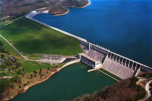
Wolf Creek Dam
| Wolf Creek Dam | |
|---|---|
 |
|
| Location | Russell County, Kentucky |
| Coordinates | 36°52′06″N 85°08′51″W / 36.8683°N 85.1475°WCoordinates: 36°52′06″N 85°08′51″W / 36.8683°N 85.1475°W |
| Construction began | 1941 |
| Opening date | 1951 |
| Operator(s) | U.S. Army Corps of Engineers |
| Dam and spillways | |
| Impounds | Cumberland River |
| Height | 258 ft (79 m) |
| Length | 5,736 ft (1,748 m) |
| Dam volume | 11,396,500 cu yd (8,713,200 m3) |
| Reservoir | |
| Creates | Lake Cumberland |
| Total capacity | 6,089,000 acre·ft (7,511,000 dam3) |
| Catchment area | 5,789 sq mi (14,990 km2) |
| Surface area | 50,250 acres (20,340 ha) |
| Power station | |
| Turbines | 6x 45.0 MW |
| Installed capacity | 270 MW |
The Wolf Creek Dam is a multi-purpose dam on the Cumberland River in the western part of Russell County, Kentucky, United States. The dam serves at once four distinct purposes: it generates hydroelectricity; it regulates and limits flooding; it releases stored water to permit year-round navigation on the lower Cumberland River; and it creates Lake Cumberland for recreation, which has become a popular tourist attraction. Because of seepage problems in the dam's foundation, it has become the U.S. Army Corps of Engineers's top dam priority. U.S. Route 127 is built on top of the dam.
Construction of the Wolf Creek Dam was authorized by the Flood Control Act of 1938 and the River Harbor Act of 1946 as part of a comprehensive plan to develop the Cumberland River Basin. Construction began in 1941 but because of World War II and other factors, construction was not completed until 1951. Lake Cumberland is one of four major flood control reservoirs for the Cumberland; the others being J. Percy Priest Dam, Dale Hollow Dam, and Center Hill Dam. The last of the power generators was installed in 1952.
While several small towns were adversely affected by the construction of the dam, such as nearby Creelsboro (downstream) and Burnside (upstream), the dam is credited with preventing several hundred million dollars in flood damage.
...
Wikipedia
