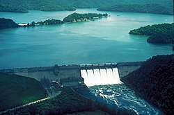
Dale Hollow Reservoir
| Dale Hollow Reservoir | |
|---|---|

Dam and Lake
|
|
| Location | Kentucky / Tennessee |
| Coordinates | 36°32′16″N 85°27′05″W / 36.537847°N 85.451317°WCoordinates: 36°32′16″N 85°27′05″W / 36.537847°N 85.451317°W |
| Type | reservoir |
| Basin countries | United States |
The Dale Hollow Reservoir is a reservoir situated on the Kentucky/Tennessee border. The lake is formed by the damming of the Obey River, 7.3 miles (12 km) above its juncture with the Cumberland River at river mile 380. Portions of the lake also cover the Wolf River. Dale Hollow is one of four major flood control reservoirs for the Cumberland; the others being J. Percy Priest Dam, Wolf Creek Dam, and Center Hill Dam. It is also the site of Dale Hollow Lake State Park on the north (Kentucky) side.
Dale Hollow Reservoir lies mainly in northern Tennessee, where it covers portions of Clay, Pickett, and Overton Counties. Small arms of the lake also extend northward into the Kentucky counties of Cumberland and Clinton. The project consists of 27,700 acres (112 km²) of water and 24,842 acres (101 km²) of surrounding land.
Dale Hollow Dam and Lake was authorized by the Flood Control Act of 1938 and the River and Harbor Act of 1946. The project was completed by the United States Army Corps of Engineers in 1943, making the lake the oldest artificial lake in Kentucky.Hydroelectric power generating units were added in 1948, 1949 and 1953. The project was designed by the Corps of Engineers and built under their supervision by private contractors. The hydroelectric generators of Dale Hollow Dam are used to supply power to the surrounding countryside. The dam, powerplant and reservoir are currently operated by the Nashville District of the Corps.
...
Wikipedia
