Bujanovac
|
Bujanovac Бујановац Bujanoci |
||
|---|---|---|
| Town and municipality | ||

Central bus station of Bujanovac
|
||
|
||
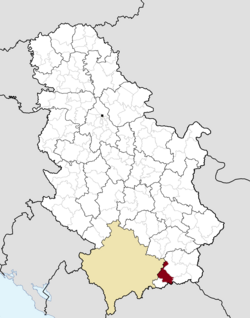
 Location of the municipality of Bujanovac within Serbia |
||
| Coordinates: 42°28′N 21°46′E / 42.467°N 21.767°ECoordinates: 42°28′N 21°46′E / 42.467°N 21.767°E | ||
| Country |
|
|
| Region | Southern and Eastern Serbia | |
| District | Pčinja | |
| Settlements | 59 | |
| Government | ||
| • Mayor | Nagip Arifi | |
| Area | ||
| • Municipality | 461 km2 (178 sq mi) | |
| Elevation | 384 m (1,260 ft) | |
| Population (2011 census) | ||
| • Municipality | 18,067 (estimated over 40,000) |
|
| Time zone | CET (UTC+1) | |
| • Summer (DST) | CEST (UTC+2) | |
| Postal code | 17520 | |
| Area code | +381(0)17 | |
| Car plates | BU | |
| Website | www |
|
Bujanovac (Serbian Cyrillic: Бујановац, pronounced [bǔjanɔvats]; Albanian: Bujanoci) is a town and municipality located in the Pčinja District of the southern Serbia. Situated in the South Morava basin, it is located in the geographical area known as Preševo Valley. It is also known for its source of mineral water and spa town Bujanovačka banja.
According to the 2002 census, the largest ethnic group in the town were Serbs, while the largest ethnic group in the municipality were Albanians.
Kale-Krševica, located south of Ristovac, is an archaeological site of a 5th-century BC Ancient city of Macedon, thought to be Damastion. The Thracian Triballi and Paeonian Agrianes dwelled in the region, with the Scordisci settling here after the Gallic invasion of the Balkans in 279 BC. The region was conquered by the Romans after 75 BC. It became part of the Roman propraetoral province Moesia in 29 BC (imperial from 27 BC). In 87 AD the region was re-organized into the Moesia Superior, which was a province of the Roman Empire.
...
Wikipedia

