Buckingham County, Virginia
| Buckingham County, Virginia | ||
|---|---|---|

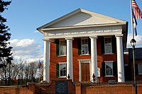
Buckingham County Courthouse
|
||
|
||
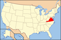
 Location in the U.S. state of Virginia |
||
 Virginia's location in the U.S. |
||
| Founded | 1761 | |
| Named for | Duke of Buckingham | |
| Seat | Buckingham | |
| Largest town | Dillwyn | |
| Area | ||
| • Total | 584 sq mi (1,513 km2) | |
| • Land | 580 sq mi (1,502 km2) | |
| • Water | 3.9 sq mi (10 km2), 0.7% | |
| Population (est.) | ||
| • (2015) | 17,032 | |
| • Density | 29/sq mi (11/km²) | |
| Congressional district | 5th | |
| Time zone | Eastern: UTC-5/-4 | |
| Website | www |
|
Buckingham County is a rural United States county located in the Commonwealth of Virginia, and containing the geographic center of the state. Buckingham County is part of the Piedmont region of Virginia, and the county seat is the town of Buckingham.
Buckingham County was created in 1761 from the southeastern portion of Albemarle County and was predominantly farmland. The county was probably named in honor of the Duke of Buckingham, though the precise origin is uncertain. Several changes were made to the borders, until the existing boundaries were established in 1860.
As of the 2010 census, the county population was 17,146. The county experienced steady population growth over the preceding forty years. Buckingham is part of the Charlottesville Metropolitan Statistical Area.
Buckingham County, lying south of the James River and in the Piedmont at the geographic center of the state, was established on May 1, 1761 from the southeastern portion of Albemarle County. The origin of the county name probably comes from the Duke of Buckingham (Buckinghamshire, England). Some sources say that the county was named for Archibald Cary's estate "Buckingham," which was located on Willis Creek. This is the only Buckingham County in the United States.
In 1778 a small triangular area bordering the James River was given to Cumberland County. In 1845, another part was taken from Buckingham to form the northern portion of Appomattox County. A final adjustment of the Appomattox-Buckingham county line was made in 1860, and Buckingham's borders then became fixed in their current form. A fire destroyed the courthouse (designed by Thomas Jefferson) in 1869, and most of the early records of this county were lost.
...
Wikipedia

