Brodivskyi Raion
|
Brodivskyi Raion Бродівський район |
|||
|---|---|---|---|
| Raion | |||
|
|||
 |
|||
| Coordinates: 50°2′30″N 25°6′47″E / 50.04167°N 25.11306°ECoordinates: 50°2′30″N 25°6′47″E / 50.04167°N 25.11306°E | |||
| Country |
|
||
| Region | Lviv Oblast | ||
| Admin. center | Brody | ||
| Subdivisions |
List
|
||
| Population (2016) | |||
| • Total | 59,225 | ||
| Time zone | EET (UTC+2) | ||
| • Summer (DST) | EEST (UTC+3) | ||
| Area code | 380-3266 | ||
| Website | http://www.brody.lviv.ua Brody | ||
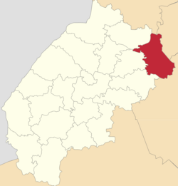
Brody Raion (Ukrainian: Бродівський район, translit: Brodivs’kyi raion) is a raion (district) of Lviv Oblast (region) of Western Ukraine. Its administrative center is Brody. Population: 59,225 (2016 est.).
The raion is located at the easternmost portion of the Lviv Region bordering with Rivne and Ternopil regions to its east, Volyn region to the north, Radekhiv district to the northwest, Busk district to the west, and Zolochiv district to the southwest.
Historically, the district (county) became known as border checkpoint between the Austria-Hungary Empire and the Russian Empire. As a county (powiat) it was established in 1866 as part of the Kingdom of Galicia and Lodomeria. After the World War I the area became part of the Second Polish Republic within the Tarnopol Voivodeship. During the World War II, during the invasion of the Soviet forces, the district was established by the Soviet administration.
The raion has a city administrative area, a "town with three other villages" administrative area and 23 rural councils which are formed out of the rest of the 73 villages. Some councils include up to 10 villages (Ponykva), while some consist only of a pair of villages.
...
Wikipedia


