Broad Channel (IND Rockaway Line)
|
Broad Channel
|
|||||||||
|---|---|---|---|---|---|---|---|---|---|
| New York City Subway rapid transit station | |||||||||

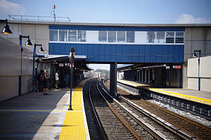
Broad Channel station after the post-Hurricane Sandy renovation
|
|||||||||
| Station statistics | |||||||||
| Address | Noel Road & West Road Queens, NY 11693 |
||||||||
| Borough | Queens | ||||||||
| Locale | Broad Channel | ||||||||
| Coordinates | 40°36′31″N 73°48′58″W / 40.608618°N 73.816°WCoordinates: 40°36′31″N 73°48′58″W / 40.608618°N 73.816°W | ||||||||
| Division | B (IND, formerly LIRR Rockaway Beach Branch) | ||||||||
| Line | IND Rockaway Line | ||||||||
| Services |
A S |
||||||||
| Transit connections |
|
||||||||
| Structure | At-grade | ||||||||
| Platforms | 2 side platforms | ||||||||
| Tracks | 2 | ||||||||
| Other information | |||||||||
| Opened | 1880 (LIRR station) | ||||||||
| Closed | 1950 (LIRR station) | ||||||||
| Rebuilt | June 28, 1956 (as a Subway station) | ||||||||
| Station code | |||||||||
| Accessibility | Same-platform wheelchair transfer available | ||||||||
| Traffic | |||||||||
| Passengers (2016) | 91,208 |
||||||||
| Rank | 421 out of 422 | ||||||||
| Station succession | |||||||||
| Next north |
Howard Beach–JFK Airport: A (Terminal): S |
||||||||
| Next south |
Beach 67th Street (Far Rockaway): A Beach 90th Street (Rockaway Park): A |
||||||||
|
|||||||||
|
|||||||||
Broad Channel is a station on the IND Rockaway Line of the New York City Subway, located in the neighborhood of the same name at Noel and West Roads in the borough of Queens. It is served by the A train and the Rockaway Park Shuttle at all times, the latter of which originates/terminates here.
This is the only subway station serving the island of Broad Channel, which is located in Jamaica Bay. The island only has about 3,000 residents, and as a result, this is the least-used station in the subway system not counting the closed Cortlandt Street station. However, this station serves an important role. It is the transfer point between the Rockaway Park Shuttle, which runs to Rockaway Park–Beach 116th Street, and the A train, which runs through Brooklyn and Manhattan.
North of this station, two additional tracks are located within the right-of-way. One of the tracks is used to allow for Rockaway Park Shuttle trains to relay and to go back into service to the Rockaways, while the other track is called the Far Rockaway Test Track. The latter of the two tracks is used to test new subway cars to make sure that they are ready for acceptance into New York City Transit's fleet of subway cars.
The station originally opened in 1880 as a New York, Woodhaven and Rockaway Railroad station (although some sources claim it opened in June 1881) and was acquired by the Long Island Rail Road, to become a station on the Rockaway Beach Branch.
As a Long Island Rail Road station it served as one of two junctions between the Far Rockaway and Rockaway Beach Branches. The other junction was at Hammels Station, although it was originally a junction for the Far Rockaway Branch and the Ocean Electric Railway. Hammels is now located where Hammels Wye is. Wooden shelter sheds were added to the station in 1921 and 1923. A fire on the trestle between this station and another one known as The Raunt, located to the north, forced the closure of both stations on May 23, 1950, as well as the entire Jamaica Bay trestle which stretches from Howard Beach to Hammels Wye.
...
Wikipedia


