Bramalea—Gore—Malton (provincial electoral district)
|
|
|||
|---|---|---|---|

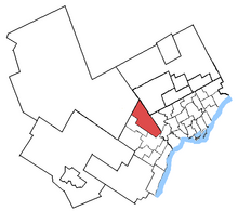
Bramalea—Gore—Malton in relation to other Greater Toronto Area electoral districts
|
|||
| Coordinates: |
43°43′13″N 79°41′14″W / 43.72028°N 79.68722°WCoordinates: 43°43′13″N 79°41′14″W / 43.72028°N 79.68722°W Location of the constituency office in Brampton (as of 3 September 2010[update]) |
||
| Provincial electoral district | |||
| Legislature | Legislative Assembly of Ontario | ||
| MPP |
Vacant |
||
| District created | 2004 | ||
| First contested | 2007 | ||
| Last contested | 2014 | ||
| Demographics | |||
| Population (2006) | 152,698 | ||
| Electors (2007) | 92,728 | ||
| Area (km²) | 151 | ||
| Pop. density (per km²) | 1,011.2 | ||
| Census divisions | Peel | ||
| Census subdivisions | Mississauga, Brampton | ||
Bramalea—Gore—Malton is a provincial electoral district in Southern Ontario, Canada. It was created for the 2007 provincial election. All of the district was carved from Bramalea—Gore—Malton—Springdale.
The riding includes the part of Mississauga north of the 401 and east of Dixie Road and the part of Brampton east of a line following Dixie Road to Bovaird Drive to Torbram Road.
In 2018, the district will be dissolved into Brampton East, Mississauga—Malton, Brampton Centre, and Brampton North.
The riding has the unusual distinction of only ever having been held by members of Canada's Sikh visible minority.
^ Change is from redistributed results
...
Wikipedia
