Bradford, Ohio
| Bradford, Ohio | |
|---|---|
| Village | |

Miami Street downtown
|
|
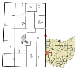
 Location in Darke County and the state of Ohio. |
|
| Coordinates: 40°7′40″N 84°25′48″W / 40.12778°N 84.43000°WCoordinates: 40°7′40″N 84°25′48″W / 40.12778°N 84.43000°W | |
| Country | United States |
| State | Ohio |
| Counties | Miami, Darke |
| Government | |
| • Mayor | Don Stump |
| Area | |
| • Total | 0.88 sq mi (2.28 km2) |
| • Land | 0.86 sq mi (2.23 km2) |
| • Water | 0.02 sq mi (0.05 km2) |
| Elevation | 988 ft (301 m) |
| Population (2010) | |
| • Total | 1,842 |
| • Estimate (2012) | 1,838 |
| • Density | 2,141.9/sq mi (827.0/km2) |
| Time zone | Eastern (EST) (UTC-5) |
| • Summer (DST) | EDT (UTC-4) |
| ZIP code | 45308 |
| Area code(s) | 937 |
| FIPS code | 39-08084 |
| GNIS feature ID | 1064474 |
| Website | http://www.bradfordoh.com/ |
Bradford is a village in Darke and Miami counties in the U.S. state of Ohio. The population was 1,842 at the 2010 census.
The Miami County portion of Bradford is part of the Dayton Metropolitan Statistical Area, while the Darke County portion is part of the Greenville Metropolitan Statistical Area.
Bradford was platted in 1865 entirely within Darke County, and it incorporated in 1871. The village was named for Tom Bradford, a railroad official. Its population was recorded at 243 by the 1870 Census. By 1890, the community had grown to 1,338 residents, the majority of whom lived in Miami County. Its growth was due to its location on the Pittsburgh, Cincinnati, Chicago and St. Louis Railroad. At Bradford, the line from Pittsburgh split into a northern branch that went to Chicago and a southern branch that went to East St. Louis. The trains took on provisions and changed crews at Bradford, and some crew members found it a convenient place to live.
Bradford is located at 40°7′40″N 84°25′48″W / 40.12778°N 84.43000°W (40.127905, -84.429927).
...
Wikipedia
