Greenville, Ohio
| Greenville, Ohio | |
|---|---|
| City | |

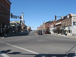
Intersection of Washington, Martin and Broadway in Greenville
|
|
| Nickname(s): "The Treaty City" | |
 Location in Darke County and the state of Ohio. |
|
| Coordinates: 40°6′9″N 84°37′41″W / 40.10250°N 84.62806°WCoordinates: 40°6′9″N 84°37′41″W / 40.10250°N 84.62806°W | |
| Country | United States |
| State | Ohio |
| County | Darke |
| Government | |
| • Mayor | Steve Willman |
| Area | |
| • Total | 6.66 sq mi (17.25 km2) |
| • Land | 6.60 sq mi (17.09 km2) |
| • Water | 0.06 sq mi (0.16 km2) |
| Elevation | 1,043 ft (318 m) |
| Population (2010) | |
| • Total | 13,227 |
| • Estimate (2012) | 13,105 |
| • Density | 2,004.1/sq mi (773.8/km2) |
| Time zone | Eastern (EST) (UTC-5) |
| • Summer (DST) | EDT (UTC-4) |
| ZIP code | 45331 |
| Area code(s) | 937 |
| FIPS code | 39-32340 |
| GNIS feature ID | 1064762 |
| Website | http://www.cityofgreenville.org/ |
Greenville is a city in and county seat of Darke County, Ohio, United States. The population was 13,227 at the 2010 census.
Greenville is the historic location of Fort Greene Ville, a pioneer fort built under General Anthony Wayne's command. At over 55 acres (220,000 m2) this was the largest wooden fortification ever built. It was here that the Treaty of Greenville was signed on August 3, 1795, bringing peace to the area and opening up the Northwest Territory for settlement. Fort Greene Ville was named for Wayne's fellow General Nathanael Greene.
Greenville is located at 40°6′9″N 84°37′41″W / 40.10250°N 84.62806°W (40.102474, -84.627985).
According to the United States Census Bureau, the city has a total area of 6.66 square miles (17.25 km2), of which 6.60 square miles (17.09 km2) is land and 0.06 square miles (0.16 km2) is water.
Local airports:
Darke County Airport, seven miles away in Versailles, Ohio
James M. Cox Dayton International Airport 35 miles away in Vandalia, Ohio
Greenville is home to The Great Darke County Fair which runs for nine days in August. Greenville is also home to KitchenAid small appliances.
...
Wikipedia
