Brügg BE
| Brügg | ||
|---|---|---|

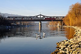
Railroad bridge between Brügg and Aegerten
|
||
|
||
| Coordinates: 47°7′N 7°17′E / 47.117°N 7.283°ECoordinates: 47°7′N 7°17′E / 47.117°N 7.283°E | ||
| Country | Switzerland | |
| Canton | Bern | |
| District | Biel/Bienne | |
| Area | ||
| • Total | 4.99 km2 (1.93 sq mi) | |
| Elevation | 485 m (1,591 ft) | |
| Population (Dec 2016) | ||
| • Total | 4,283 | |
| • Density | 860/km2 (2,200/sq mi) | |
| Postal code | 2555 | |
| SFOS number | 0733 | |
| Surrounded by | Aegerten, Biel/Bienne, Orpund, Port, Schwadernau | |
| Website |
www SFSO statistics |
|
Brügg is a municipality in the Biel/Bienne administrative district in the canton of Bern in Switzerland.
Brügg is first mentioned in 1261 as Brugge. A Hallstatt culture tumulus near the city indicates that his area was settled anciently. During the late Roman Empire era it gained importance as a bridge on the Roman road from Petinesca over the Mett in the Jura mountains. The Zihl River was built in 368-369 and its ruins are still is visible on an island in the river and below the church in Bürglen (now part of Aegerten).
In the Late Middle Ages, Brügg belonged to the Grafschaft (county) of Nidau. Along with the rest of the county, Brügg was partly incorporated into Bernese territory in 1388 with the remaining rights coming to Bern in 1393. As part of the Bernese county of Nidau, Brügg, Aegerten and the village of Bürglen were known as the Brüggviertel (Brügg Quarter). The main land owners in Brügg were the House of Kyburg and Gottstatt Abbey. During the Middle Ages the Roman bridge was replaced with a ferry. Despite being separated from Bürglen by the Zihl river, Brügg was part of the parish of Bürglen and was closely tied to the communities across the river. The communities shared a school until a school opened in Brügg in 1683. Brügg had its own cemetery beginning in 1900 and became an independent parish in 1971. From the collapse of the Roman bridge until 1832, the only way across the river was a ferry.
...
Wikipedia


