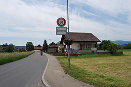
Schwadernau
| Schwadernau | ||
|---|---|---|
 |
||
|
||
| Coordinates: 47°8′N 7°18′E / 47.133°N 7.300°ECoordinates: 47°8′N 7°18′E / 47.133°N 7.300°E | ||
| Country | Switzerland | |
| Canton | Bern | |
| District | Biel/Bienne | |
| Area | ||
| • Total | 4.14 km2 (1.60 sq mi) | |
| Elevation | 437 m (1,434 ft) | |
| Population (Dec 2015) | ||
| • Total | 657 | |
| • Density | 160/km2 (410/sq mi) | |
| Postal code | 2556 | |
| SFOS number | 0748 | |
| Surrounded by | Aegerten, Brügg, Büetigen, Dotzigen, Orpund, Scheuren, Studen | |
| Website |
www SFSO statistics |
|
Schwadernau is a municipality in the Biel/Bienne administrative district in the canton of Bern in Switzerland.
Schwadernau is first mentioned in 1269 as Swadernouwa.
A number of artifacts indicate that the area around Schwadernau has been inhabited since the Upper Paleolithic. In addition to neolithic finds, many Bronze Age, Roman era and early medieval objects indicate that there were other prehistoric settlements near the modern municipality. A depot of iron ingots and the remains of a Roman wall show that there may have been a workshop or small settlement near the Räbhubel or Scheurenhubel. During the Middle Ages, the village was owned by the Counts of Neuchâtel-Nidau. In 1281, the Count gave about half of the village to the Prince-Bishop of Basel. In 1376 the Counts of Kyburg and Thierstein fought and defeated the Bishop of Basel outside Schwadernau. In 1398 the entire Inselgau region, including Schwadernau, was acquired by the city of Bern. Under Bernese rule, the village became part of the bailiwick of Nidau and the parish of Bürglen.
The Jura water correction projects and the construction of the Nidau-Büren Canal between 1868 and 1875 drained the marshes around the village, prevented flooding and opened up rich farmland. Today, almost one-fourth of the jobs in the village are in agriculture.
Schwadernau has an area of 4.14 km2 (1.60 sq mi). As of 2012, a total of 3.06 km2 (1.18 sq mi) or 73.9% is used for agricultural purposes, while 0.6 km2 (0.23 sq mi) or 14.5% is forested. The rest of the municipality is 0.42 km2 (0.16 sq mi) or 10.1% is settled (buildings or roads), 0.04 km2 (9.9 acres) or 1.0% is either rivers or lakes.
...
Wikipedia


