Büetigen
| Büetigen | ||
|---|---|---|

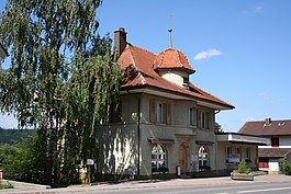
Büetigen town hall (Gemeindehaus)
|
||
|
||
| Coordinates: 47°6′N 7°21′E / 47.100°N 7.350°ECoordinates: 47°6′N 7°21′E / 47.100°N 7.350°E | ||
| Country | Switzerland | |
| Canton | Bern | |
| District | Seeland | |
| Government | ||
| • Mayor |
Gemeindepräsident Fritz Linder SVP/UDC (as of 2008) |
|
| Area | ||
| • Total | 3.61 km2 (1.39 sq mi) | |
| Elevation | 448 m (1,470 ft) | |
| Population (Dec 2015) | ||
| • Total | 833 | |
| • Density | 230/km2 (600/sq mi) | |
| Postal code | 3263 | |
| SFOS number | 0382 | |
| Surrounded by | Busswil bei Büren, Diessbach bei Büren, Dotzigen, Schwadernau, Studen, and Lyss | |
| Website |
www SFSO statistics |
|
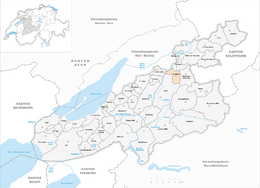
Büetigen is a municipality in the Seeland administrative district in the canton of Bern in Switzerland.
Büetigen is first mentioned in 1261 as Buetingen.
The earliest trace of humans in Büetigen are scattered mesolithic and neolithic tools and items. La Tene era graves and an early medieval cemetery have also been found. The Burghubel hill was probably the family seat of the Ministerialis (unfree knights in the service of a feudal overlord) family of Büetigen. The family was first mentioned in the 13th century, but no trace of their castle has been discovered. Eventually the village passed from the Büetigen family to St. Urban's Abbey and Frienisberg Abbey. Frienisberg Abbey gradually replaced all the other landholders in the village to become the sole landlord. However, in 1365 the Büetigen jurisdiction transferred to the Bernese Vogt in Aarberg. Fifteen years later, in 1380, the court and jurisdiction were sold directly to Bern. After the secularization of the Abbey, in 1528 during the Protestant Reformation, Bern acquired all the Abbey's lands. Büetigen became part of the new bailiwick of Frienisberg while the military administration and the high court was in Büren. After the 1798 French invasion, the village of Büetigen, without the surrounding farms, became part of the Helvetic Republic's Büren district.
...
Wikipedia


