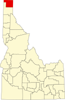
Boundary County
| Boundary County, Idaho | ||
|---|---|---|

Boundary County Courthouse
|
||
|
||
 Location in the U.S. state of Idaho |
||
 Idaho's location in the U.S. |
||
| Founded | January 23, 1915 | |
| Named for | national border | |
| Seat | Bonners Ferry | |
| Largest city | Bonners Ferry | |
| Area | ||
| • Total | 1,278 sq mi (3,310 km2) | |
| • Land | 1,269 sq mi (3,287 km2) | |
| • Water | 9.3 sq mi (24 km2), 0.7% | |
| Population | ||
| • (2010) | 10,972 | |
| • Density | 8.6/sq mi (3/km²) | |
| Congressional district | 1st | |
| Time zone | Pacific: UTC-8/-7 | |
| Website | www |
|
Coordinates: 48°47′N 116°27′W / 48.79°N 116.45°W
Boundary County is a county located in the U.S. state of Idaho. As of the 2010 census, the population was 10,972. The county seat and largest city is Bonners Ferry.
Boundary County was created by the Idaho Legislature on January 23, 1915. It is so named because it borders Canada, the only county in Idaho with an international border.
Boundary County was formed on January 23, 1915 from Bonner County. It was named Boundary County because it lies on the border of Canada, Washington and Montana.
Bonner County is presently divided into 7 election precincts: Bonners Ferry, Copeland, Kootenai, Moyie, Naples, North Bonners Ferry, and Valley View. All contain a portion of Bonners Ferry City except Copeland, Moyie, and Naples precincts. Moyie Springs was incorporated in 1947.
Settlement of the area started with the establishment of Bonners Ferry on the Kootenai River in 1864. Settlement was limited to the ferry operation until about 1890. The town of Bonners Ferry was established in 1893. At that point settlement was still sparse with small ranching and mining operations, but an expanding timber economy. By 1900, other areas started to develop with the Boulder (now Kootenai), Boundary (now Copeland), and Naples precincts first listed in the U.S. Census of that year. The Moyie precinct first appeared in the 1910 census.
...
Wikipedia

