Borzya
| Borzya (English) Борзя (Russian) |
|
|---|---|
| - Town - | |
 Borzya railway station |
|
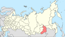
 Location of Zabaykalsky Krai in Russia |
|
|
|
|
|
|
|
|
|
|
| Administrative status (as of January 2014) | |
| Country | Russia |
| Federal subject | Zabaykalsky Krai |
| Administrative district | Borzinsky District |
| Administrative center of | Borzinsky District |
| Municipal status (as of December 2012) | |
| Municipal district | Borzinsky Municipal District |
| Urban settlement | Borzinskoye Urban Settlement |
| Administrative center of | Borzinsky Municipal District, Borzinskoye Urban Settlement |
| Statistics | |
| Population (2010 Census) | 31,379 inhabitants |
| Population (January 2014 est.) | 29,822 inhabitants |
| Time zone | YAKT (UTC+09:00) |
| Founded | 18th century |
| Town status since | 1950 |
| Postal code(s) | 674600–674603, 674609 |
| Dialing code(s) | +7 30233 |
| on | |
Borzya (Russian: Борзя; IPA: [ˈborzʲə]) is a town and the administrative center of Borzinsky District in Zabaykalsky Krai, Russia, located 349 kilometers (217 mi) southeast of Chita, the administrative center of the krai. Population: 31,379 (2010 Census);31,460 (2002 Census);36,373 (1989 Census).
The town is located on the Borzya River—a right-hand tributary of the Onon—about 40 kilometers (25 mi) from the border with Mongolia in the south and 70 kilometers (43 mi) from the border with China in the southeast.
Borzya has a subarctic climate (Köppen climate classification Dwc) bordering on humid continental (Köppen climate classification Dwb) and semi-arid climate (Köppen climate classification BSk), with severely cold winters and warm summers. Precipitation is quite low but is somewhat higher from June to September than at other times of the year.
...
Wikipedia


