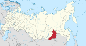
Zabaykalsky Krai
|
Zabaykalsky Krai Забайкальский край (Russian) |
|||
|---|---|---|---|
| — Krai — | |||
|
|||
|
|
|||
|
|||
|
|
|||
| Political status | |||
| Country | Russia | ||
| Federal district | Siberian | ||
| Economic region | East Siberian | ||
| Established | March 1, 2008 | ||
| Krai Day | March 1 | ||
| Administrative center | Chita | ||
| Government (as of June 2015) | |||
| • Governor | Natalia Zhdanova | ||
| • Legislature | Legislative Assembly | ||
| Statistics | |||
| Area (as of the 2002 Census) | |||
| • Total | 431,500 km2 (166,600 sq mi) | ||
| Area rank | 10th | ||
| Population (2010 Census) | |||
| • Total | 1,107,107 | ||
| • Rank | 47th | ||
| • Density | 2.57/km2 (6.7/sq mi) | ||
| • Urban | 65.9% | ||
| • Rural | 34.1% | ||
| Population (January 2015 est.) | |||
| • Total | 1,087,500 | ||
| Time zone(s) | YAKT (UTC+09:00) | ||
| ISO 3166-2 | RU-ZAB | ||
| License plates | 75, 80 | ||
| Official languages | Russian | ||
| Official website | |||
|
|
|---|
Zabaykalsky Krai (Russian: Забайкальский край, tr. Zabaykalsky kray; IPA: [zəbɐjˈkalʲskʲɪj kraj], lit. Transbaikal krai) is a federal subject of Russia (a krai) that was created on March 1, 2008 as a result of a merger of Chita Oblast and Agin-Buryat Autonomous Okrug, after a referendum held on the issue on March 11, 2007. The administrative center of the krai is located in the city of Chita. As of the 2010 Census, the population was 1,107,107.
The krai is located within the historical region of Transbaikalia and has extensive international borders with China (998 km) and Mongolia (868 km); its internal borders are with Irkutsk and Amur Oblasts, as well as with the Republic of Buryatia and the Sakha Republic.
The first traces of human presence in the area dates to 150-35 thousand years ago. Early evidence was found on the surface of ancient river gravels Gyrshelunki (tributary of the Khilok River) near the city of Chita, near Ust-Menza on the Chikoy River.
...
Wikipedia


