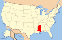
Bolivar County, MS
| Bolivar County, Mississippi | |
|---|---|
 Location in the U.S. state of Mississippi |
|
 Mississippi's location in the U.S. |
|
| Founded | 1836 |
| Named for | Simón Bolívar |
| Seat | Rosedale and Cleveland |
| Largest city | Cleveland |
| Area | |
| • Total | 906 sq mi (2,347 km2) |
| • Land | 877 sq mi (2,271 km2) |
| • Water | 29 sq mi (75 km2), 3.2% |
| Population | |
| • (2010) | 34,145 |
| • Density | 39/sq mi (15/km²) |
| Congressional district | 2nd |
| Time zone | Central: UTC-6/-5 |
| Website | www |
Bolivar County is a county located in the U.S. state of Mississippi. As of the 2010 census, the population was 34,145. Its county seats are Rosedale and Cleveland. The county is named in honor of Simón Bolívar, early 19th-century leader of the liberation of several South American colonies from Spain.
The Cleveland, MS Micropolitan Statistical Area includes all of Bolivar County. It is located in the Mississippi Delta, or Yazoo Basin, of Mississippi. This area was first developed for cotton plantations. Large industrial operations have reduced the number of farm workers needed. Today soybeans are also a commodity crop.
According to the U.S. Census Bureau, the county has a total area of 906 square miles (2,350 km2), of which 877 square miles (2,270 km2) is land and 29 square miles (75 km2) (3.2%) is water. It is the second-largest county in Mississippi by land area and fourth-largest by total area.
As of the 2010 United States Census, there were 34,145 people residing in the county. 64.5% were Black or African American, 33.5% White, 0.6% Asian, 0.1% Native American, 0.9% of some other race and 0.6% of two or more races. 1.9% were Hispanic or Latino (of any race).
...
Wikipedia
